You are here: Home > Network List > CI - Caltech Regional Seismic Network Stations List
> Station RCT Rector, Visalia, CA, USA > Earthquake Result Viewer
RCT Rector, Visalia, CA, USA - Earthquake Result Viewer
| Earthquake location: |
Ryukyu Islands, Japan |
| Earthquake latitude/longitude: |
27.5/128.4 |
| Earthquake time(UTC): |
2007/04/20 (110) 19:37:58 GMT |
| Earthquake Depth: |
42 km |
| Earthquake Magnitude: |
5.9 MB, 5.1 MS, 5.7 MW, 5.7 MW |
| Earthquake Catalog/Contributor: |
WHDF/NEIC |
|
| Network: |
CI Caltech Regional Seismic Network |
| Station: |
RCT Rector, Visalia, CA, USA |
| Lat/Lon: |
36.31 N/119.24 W |
| Elevation: |
107 m |
|
| Distance: |
90.2 deg |
| Az: |
48.326 deg |
| Baz: |
304.754 deg |
| Ray Param: |
0.041687407 |
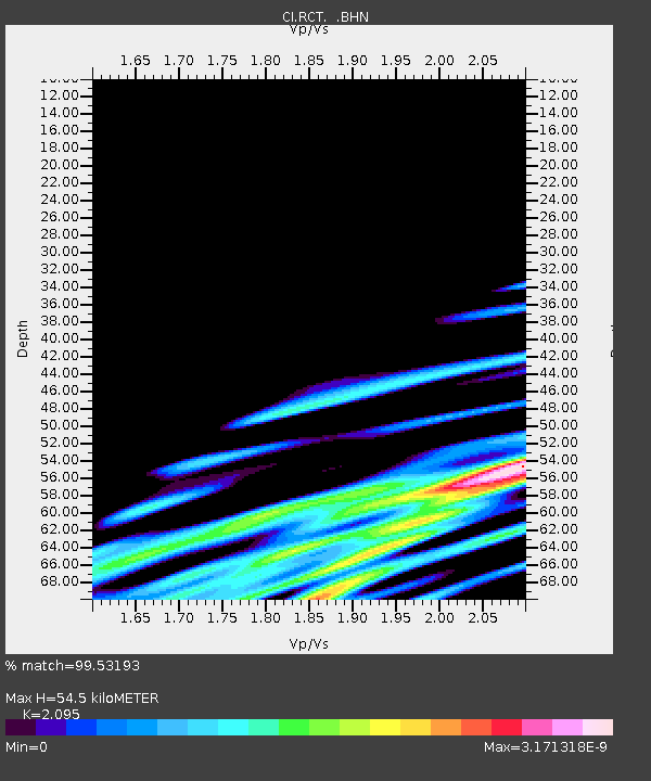
| Estimated Moho Depth: |
54.5 km |
| Estimated Crust Vp/Vs: |
2.10 |
| Assumed Crust Vp: |
6.291 km/s |
| Estimated Crust Vs: |
3.003 km/s |
| Estimated Crust Poisson's Ratio: |
0.35 |
|
| Radial Match: |
99.53193 % |
| Radial Bump: |
36 |
| Transverse Match: |
99.707886 % |
| Transverse Bump: |
25 |
| SOD ConfigId: |
2564 |
| Insert Time: |
2010-03-05 22:12:07.779 +0000 |
| GWidth: |
2.5 |
| Max Bumps: |
400 |
| Tol: |
0.001 |
|
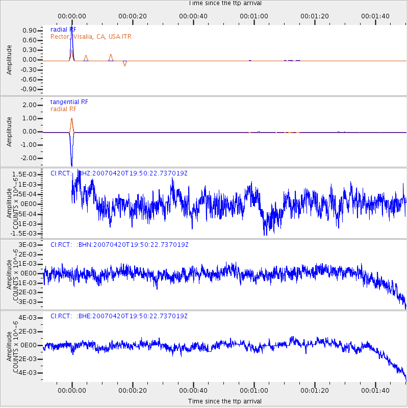
Signal To Noise
| Channel | StoN | STA | LTA |
| CI:RCT: :BHN:20070420T19:50:22.737019Z | 0.85302305 | 5.4008326E-10 | 6.331403E-10 |
| CI:RCT: :BHE:20070420T19:50:22.737019Z | 0.69800955 | 4.80619E-10 | 6.8855643E-10 |
| CI:RCT: :BHZ:20070420T19:50:22.737019Z | 0.76304084 | 4.242618E-10 | 5.560145E-10 |
| Arrivals |
| Ps | 9.6 SECOND |
| PpPs | 26 SECOND |
| PsPs/PpSs | 36 SECOND |


