You are here: Home > Network List > CI - Caltech Regional Seismic Network Stations List
> Station RCT Rector, Visalia, CA, USA > Earthquake Result Viewer
RCT Rector, Visalia, CA, USA - Earthquake Result Viewer
| Earthquake location: |
South Of Kermadec Islands |
| Earthquake latitude/longitude: |
-34.0/-178.8 |
| Earthquake time(UTC): |
2007/04/20 (110) 15:14:07 GMT |
| Earthquake Depth: |
7.8 km |
| Earthquake Magnitude: |
5.5 MB, 5.2 MS, 5.5 MW |
| Earthquake Catalog/Contributor: |
WHDF/NEIC |
|
| Network: |
CI Caltech Regional Seismic Network |
| Station: |
RCT Rector, Visalia, CA, USA |
| Lat/Lon: |
36.31 N/119.24 W |
| Elevation: |
107 m |
|
| Distance: |
89.4 deg |
| Az: |
44.163 deg |
| Baz: |
225.754 deg |
| Ray Param: |
0.041913025 |
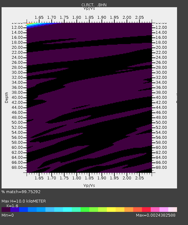
| Estimated Moho Depth: |
10.0 km |
| Estimated Crust Vp/Vs: |
1.60 |
| Assumed Crust Vp: |
6.291 km/s |
| Estimated Crust Vs: |
3.932 km/s |
| Estimated Crust Poisson's Ratio: |
0.18 |
|
| Radial Match: |
99.75292 % |
| Radial Bump: |
25 |
| Transverse Match: |
98.713715 % |
| Transverse Bump: |
56 |
| SOD ConfigId: |
2564 |
| Insert Time: |
2010-03-05 22:12:09.987 +0000 |
| GWidth: |
2.5 |
| Max Bumps: |
400 |
| Tol: |
0.001 |
|
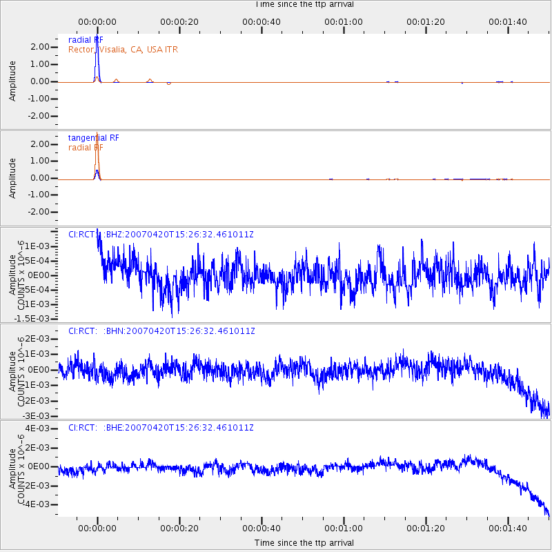
Signal To Noise
| Channel | StoN | STA | LTA |
| CI:RCT: :BHN:20070420T15:26:32.461011Z | 1.354892 | 6.1644506E-10 | 4.5497728E-10 |
| CI:RCT: :BHE:20070420T15:26:32.461011Z | 0.6681805 | 3.721468E-10 | 5.569555E-10 |
| CI:RCT: :BHZ:20070420T15:26:32.461011Z | 0.8101776 | 4.1447223E-10 | 5.1158194E-10 |
| Arrivals |
| Ps | 1.0 SECOND |
| PpPs | 4.0 SECOND |
| PsPs/PpSs | 5.0 SECOND |


