You are here: Home > Network List > CI - Caltech Regional Seismic Network Stations List
> Station RCT Rector, Visalia, CA, USA > Earthquake Result Viewer
RCT Rector, Visalia, CA, USA - Earthquake Result Viewer

| Earthquake location: |
Southwestern Ryukyu Isl., Japan |
| Earthquake latitude/longitude: |
25.6/125.0 |
| Earthquake time(UTC): |
2007/04/20 (110) 02:23:34 GMT |
| Earthquake Depth: |
11 km |
| Earthquake Magnitude: |
5.7 MB, 5.9 MS, 5.9 MW |
| Earthquake Catalog/Contributor: |
WHDF/NEIC |
|
| Network: |
CI Caltech Regional Seismic Network |
| Station: |
RCT Rector, Visalia, CA, USA |
| Lat/Lon: |
36.31 N/119.24 W |
| Elevation: |
107 m |
|
| Distance: |
93.6 deg |
| Az: |
46.821 deg |
| Baz: |
305.413 deg |
| Ray Param: |
0.041227493 |
| Estimated Moho Depth: |
29.0 km |
| Estimated Crust Vp/Vs: |
1.73 |
| Assumed Crust Vp: |
6.291 km/s |
| Estimated Crust Vs: |
3.631 km/s |
| Estimated Crust Poisson's Ratio: |
0.25 |
|
| Radial Match: |
99.36788 % |
| Radial Bump: |
44 |
| Transverse Match: |
99.749016 % |
| Transverse Bump: |
26 |
| SOD ConfigId: |
2564 |
| Insert Time: |
2010-03-05 22:12:11.698 +0000 |
| GWidth: |
2.5 |
| Max Bumps: |
400 |
| Tol: |
0.001 |
|
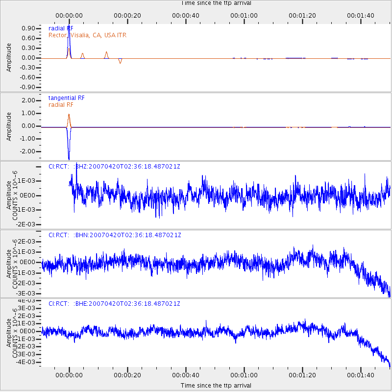
Signal To Noise
| Channel | StoN | STA | LTA |
| CI:RCT: :BHN:20070420T02:36:18.487021Z | 1.0280035 | 5.376952E-10 | 5.2304805E-10 |
| CI:RCT: :BHE:20070420T02:36:18.487021Z | 1.209034 | 6.798107E-10 | 5.62276E-10 |
| CI:RCT: :BHZ:20070420T02:36:18.487021Z | 0.9601714 | 4.986196E-10 | 5.193027E-10 |
| Arrivals |
| Ps | 3.4 SECOND |
| PpPs | 12 SECOND |
| PsPs/PpSs | 16 SECOND |


