You are here: Home > Network List > CI - Caltech Regional Seismic Network Stations List
> Station RCT Rector, Visalia, CA, USA > Earthquake Result Viewer
RCT Rector, Visalia, CA, USA - Earthquake Result Viewer
| Earthquake location: |
Kuril Islands |
| Earthquake latitude/longitude: |
47.0/153.4 |
| Earthquake time(UTC): |
2007/04/15 (105) 04:12:30 GMT |
| Earthquake Depth: |
35 km |
| Earthquake Magnitude: |
5.6 MB, 5.0 MS, 5.5 MW, 5.5 MW |
| Earthquake Catalog/Contributor: |
WHDF/NEIC |
|
| Network: |
CI Caltech Regional Seismic Network |
| Station: |
RCT Rector, Visalia, CA, USA |
| Lat/Lon: |
36.31 N/119.24 W |
| Elevation: |
107 m |
|
| Distance: |
62.9 deg |
| Az: |
65.018 deg |
| Baz: |
309.823 deg |
| Ray Param: |
0.059870612 |
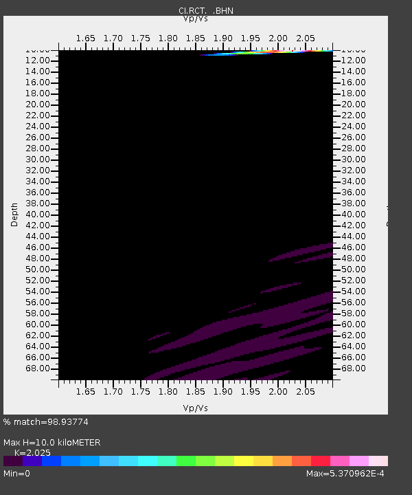
| Estimated Moho Depth: |
10.0 km |
| Estimated Crust Vp/Vs: |
2.03 |
| Assumed Crust Vp: |
6.291 km/s |
| Estimated Crust Vs: |
3.107 km/s |
| Estimated Crust Poisson's Ratio: |
0.34 |
|
| Radial Match: |
98.93774 % |
| Radial Bump: |
52 |
| Transverse Match: |
99.73891 % |
| Transverse Bump: |
30 |
| SOD ConfigId: |
2564 |
| Insert Time: |
2010-03-05 22:12:15.013 +0000 |
| GWidth: |
2.5 |
| Max Bumps: |
400 |
| Tol: |
0.001 |
|
Signal To Noise
| Channel | StoN | STA | LTA |
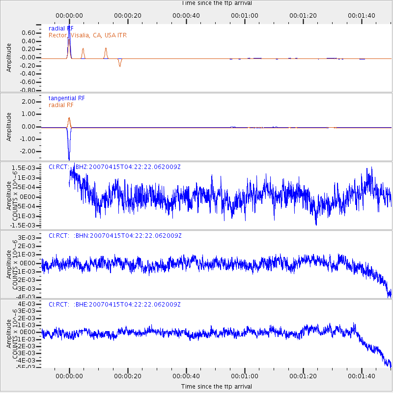
| CI:RCT: :BHN:20070415T04:22:22.062009Z | 0.8911485 | 4.370204E-10 | 4.9040133E-10 |
| CI:RCT: :BHE:20070415T04:22:22.062009Z | 1.0707656 | 5.347366E-10 | 4.993965E-10 |
| CI:RCT: :BHZ:20070415T04:22:22.062009Z | 0.87287956 | 5.0531346E-10 | 5.7890404E-10 |
| Arrivals |
| Ps | 1.7 SECOND |
| PpPs | 4.6 SECOND |
| PsPs/PpSs | 6.3 SECOND |


