You are here: Home > Network List > CI - Caltech Regional Seismic Network Stations List
> Station RCT Rector, Visalia, CA, USA > Earthquake Result Viewer
RCT Rector, Visalia, CA, USA - Earthquake Result Viewer
| Earthquake location: |
Kuril Islands |
| Earthquake latitude/longitude: |
48.3/154.7 |
| Earthquake time(UTC): |
2007/04/09 (099) 10:18:04 GMT |
| Earthquake Depth: |
36 km |
| Earthquake Magnitude: |
5.8 MB, 5.4 MS, 5.8 MW, 5.7 MW |
| Earthquake Catalog/Contributor: |
WHDF/NEIC |
|
| Network: |
CI Caltech Regional Seismic Network |
| Station: |
RCT Rector, Visalia, CA, USA |
| Lat/Lon: |
36.31 N/119.24 W |
| Elevation: |
107 m |
|
| Distance: |
61.6 deg |
| Az: |
66.387 deg |
| Baz: |
310.768 deg |
| Ray Param: |
0.06072037 |
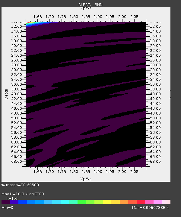
| Estimated Moho Depth: |
10.0 km |
| Estimated Crust Vp/Vs: |
1.60 |
| Assumed Crust Vp: |
6.291 km/s |
| Estimated Crust Vs: |
3.932 km/s |
| Estimated Crust Poisson's Ratio: |
0.18 |
|
| Radial Match: |
98.69588 % |
| Radial Bump: |
48 |
| Transverse Match: |
99.75411 % |
| Transverse Bump: |
32 |
| SOD ConfigId: |
2564 |
| Insert Time: |
2010-03-05 22:12:18.640 +0000 |
| GWidth: |
2.5 |
| Max Bumps: |
400 |
| Tol: |
0.001 |
|
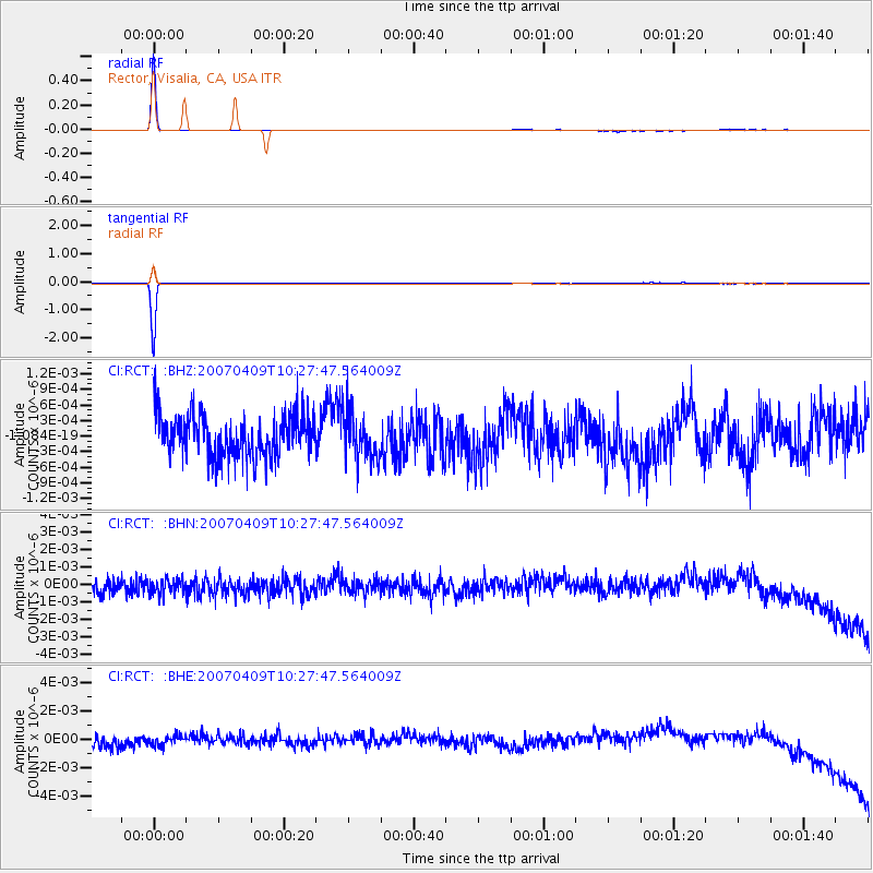
Signal To Noise
| Channel | StoN | STA | LTA |
| CI:RCT: :BHN:20070409T10:27:47.564009Z | 0.9508041 | 4.3372575E-10 | 4.561673E-10 |
| CI:RCT: :BHE:20070409T10:27:47.564009Z | 0.73052055 | 4.629991E-10 | 6.337934E-10 |
| CI:RCT: :BHZ:20070409T10:27:47.564009Z | 1.1567864 | 4.688062E-10 | 4.05266E-10 |
| Arrivals |
| Ps | 1.0 SECOND |
| PpPs | 3.9 SECOND |
| PsPs/PpSs | 4.9 SECOND |


