You are here: Home > Network List > CI - Caltech Regional Seismic Network Stations List
> Station RCT Rector, Visalia, CA, USA > Earthquake Result Viewer
RCT Rector, Visalia, CA, USA - Earthquake Result Viewer
| Earthquake location: |
Mariana Islands |
| Earthquake latitude/longitude: |
21.0/144.7 |
| Earthquake time(UTC): |
2007/01/30 (030) 21:37:45 GMT |
| Earthquake Depth: |
30 km |
| Earthquake Magnitude: |
6.3 MB, 6.5 MS, 6.6 MW, 6.5 MW |
| Earthquake Catalog/Contributor: |
WHDF/NEIC |
|
| Network: |
CI Caltech Regional Seismic Network |
| Station: |
RCT Rector, Visalia, CA, USA |
| Lat/Lon: |
36.31 N/119.24 W |
| Elevation: |
107 m |
|
| Distance: |
82.5 deg |
| Az: |
54.11 deg |
| Baz: |
290.409 deg |
| Ray Param: |
0.046793077 |
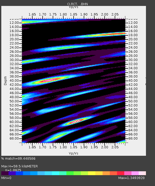
| Estimated Moho Depth: |
59.5 km |
| Estimated Crust Vp/Vs: |
1.86 |
| Assumed Crust Vp: |
6.291 km/s |
| Estimated Crust Vs: |
3.378 km/s |
| Estimated Crust Poisson's Ratio: |
0.30 |
|
| Radial Match: |
89.448586 % |
| Radial Bump: |
400 |
| Transverse Match: |
76.30965 % |
| Transverse Bump: |
400 |
| SOD ConfigId: |
2564 |
| Insert Time: |
2010-03-05 22:12:27.540 +0000 |
| GWidth: |
2.5 |
| Max Bumps: |
400 |
| Tol: |
0.001 |
|
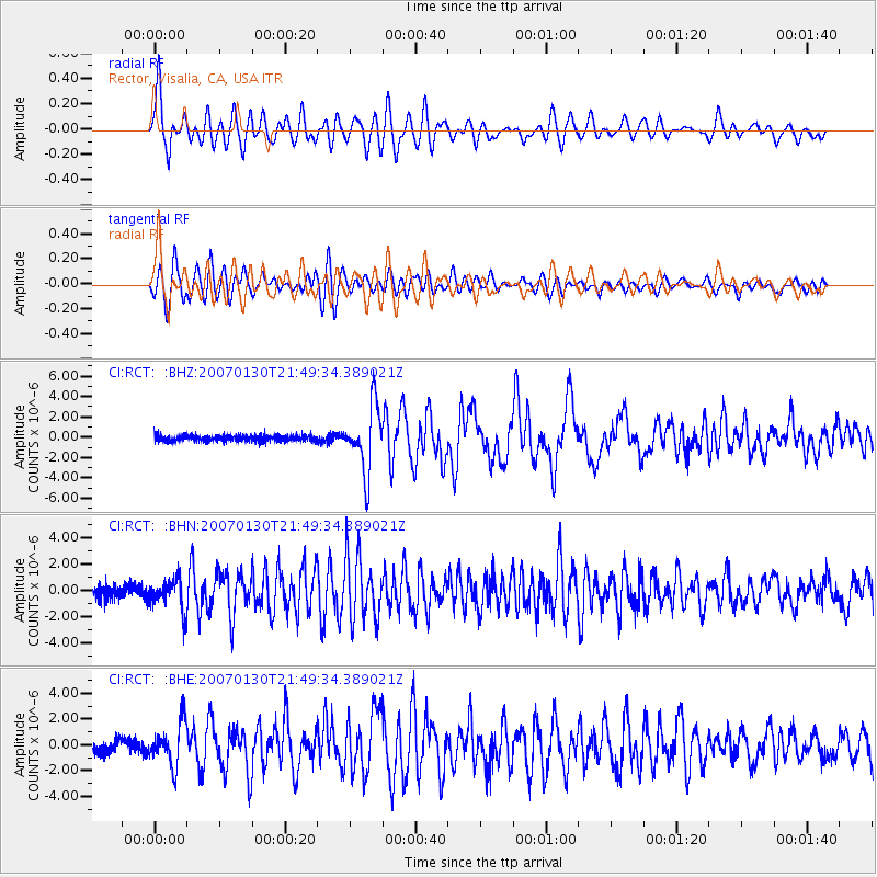
Signal To Noise
| Channel | StoN | STA | LTA |
| CI:RCT: :BHN:20070130T21:49:34.389021Z | 2.22784 | 1.1735109E-6 | 5.267483E-7 |
| CI:RCT: :BHE:20070130T21:49:34.389021Z | 2.880441 | 1.6342487E-6 | 5.673606E-7 |
| CI:RCT: :BHZ:20070130T21:49:34.389021Z | 11.003722 | 3.193426E-6 | 2.9021325E-7 |
| Arrivals |
| Ps | 8.4 SECOND |
| PpPs | 26 SECOND |
| PsPs/PpSs | 35 SECOND |


