You are here: Home > Network List > CI - Caltech Regional Seismic Network Stations List
> Station RCT Rector, Visalia, CA, USA > Earthquake Result Viewer
RCT Rector, Visalia, CA, USA - Earthquake Result Viewer
| Earthquake location: |
Andreanof Islands, Aleutian Is. |
| Earthquake latitude/longitude: |
51.9/-179.2 |
| Earthquake time(UTC): |
2008/04/16 (107) 05:54:19 GMT |
| Earthquake Depth: |
13 km |
| Earthquake Magnitude: |
6.1 MB, 6.5 MS, 6.6 MW, 6.6 MW |
| Earthquake Catalog/Contributor: |
WHDF/NEIC |
|
| Network: |
CI Caltech Regional Seismic Network |
| Station: |
RCT Rector, Visalia, CA, USA |
| Lat/Lon: |
36.31 N/119.24 W |
| Elevation: |
107 m |
|
| Distance: |
44.5 deg |
| Az: |
86.091 deg |
| Baz: |
310.036 deg |
| Ray Param: |
0.07188509 |
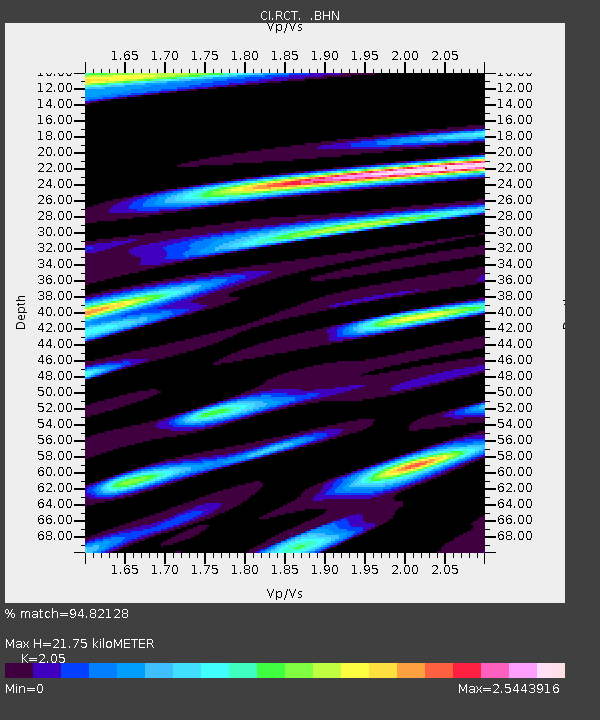
| Estimated Moho Depth: |
21.75 km |
| Estimated Crust Vp/Vs: |
2.05 |
| Assumed Crust Vp: |
6.291 km/s |
| Estimated Crust Vs: |
3.069 km/s |
| Estimated Crust Poisson's Ratio: |
0.34 |
|
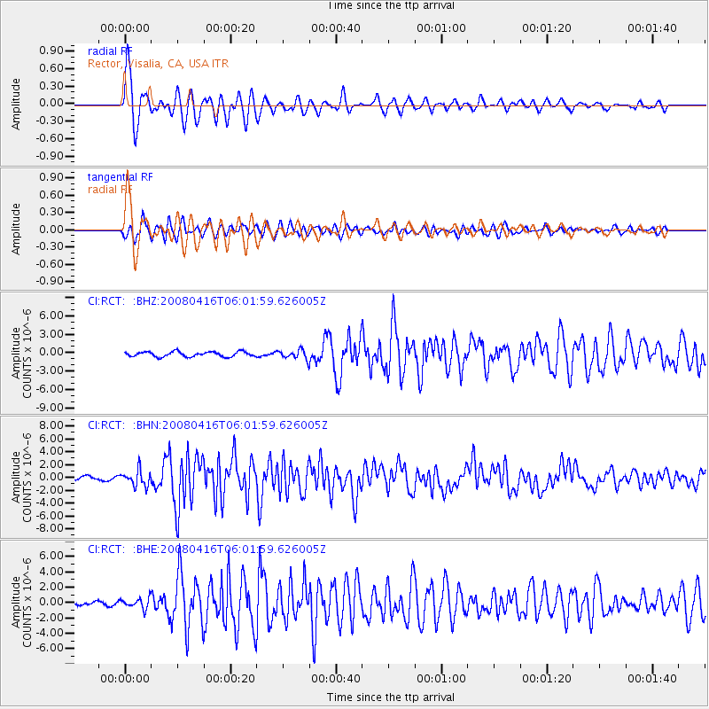
| Radial Match: |
94.82128 % |
| Radial Bump: |
400 |
| Transverse Match: |
86.499374 % |
| Transverse Bump: |
400 |
| SOD ConfigId: |
2504 |
| Insert Time: |
2010-03-05 22:12:35.861 +0000 |
| GWidth: |
2.5 |
| Max Bumps: |
400 |
| Tol: |
0.001 |
|
Signal To Noise
| Channel | StoN | STA | LTA |
| CI:RCT: :BHN:20080416T06:01:59.626005Z | 4.1663575 | 1.2250032E-6 | 2.940226E-7 |
| CI:RCT: :BHE:20080416T06:01:59.626005Z | 2.8429475 | 6.6367454E-7 | 2.3344595E-7 |
| CI:RCT: :BHZ:20080416T06:01:59.626005Z | 1.852087 | 7.3970244E-7 | 3.993886E-7 |
| Arrivals |
| Ps | 3.8 SECOND |
| PpPs | 10.0 SECOND |
| PsPs/PpSs | 14 SECOND |


