You are here: Home > Network List > CI - Caltech Regional Seismic Network Stations List
> Station RCT Rector, Visalia, CA, USA > Earthquake Result Viewer
RCT Rector, Visalia, CA, USA - Earthquake Result Viewer
| Earthquake location: |
Andreanof Islands, Aleutian Is. |
| Earthquake latitude/longitude: |
52.2/-178.7 |
| Earthquake time(UTC): |
2008/03/22 (082) 21:24:11 GMT |
| Earthquake Depth: |
132 km |
| Earthquake Magnitude: |
5.8 MB, 6.2 MW, 6.1 MW |
| Earthquake Catalog/Contributor: |
WHDF/NEIC |
|
| Network: |
CI Caltech Regional Seismic Network |
| Station: |
RCT Rector, Visalia, CA, USA |
| Lat/Lon: |
36.31 N/119.24 W |
| Elevation: |
107 m |
|
| Distance: |
44.2 deg |
| Az: |
86.731 deg |
| Baz: |
310.437 deg |
| Ray Param: |
0.07161343 |
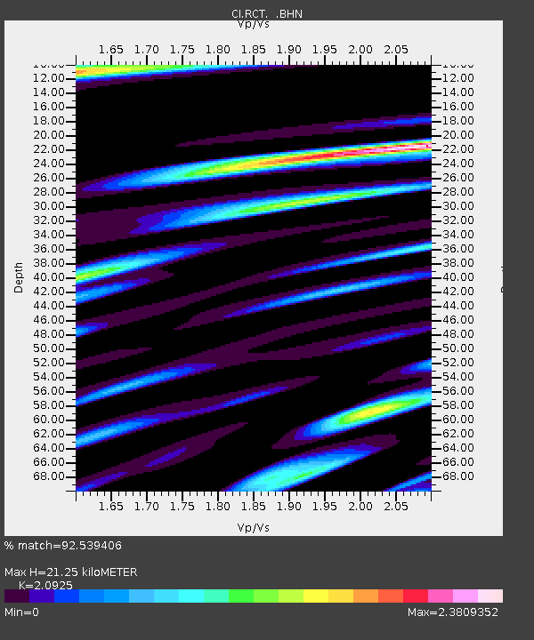
| Estimated Moho Depth: |
21.25 km |
| Estimated Crust Vp/Vs: |
2.09 |
| Assumed Crust Vp: |
6.291 km/s |
| Estimated Crust Vs: |
3.007 km/s |
| Estimated Crust Poisson's Ratio: |
0.35 |
|
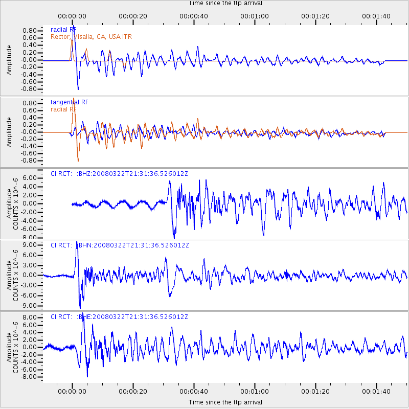
| Radial Match: |
92.539406 % |
| Radial Bump: |
400 |
| Transverse Match: |
71.57141 % |
| Transverse Bump: |
400 |
| SOD ConfigId: |
2504 |
| Insert Time: |
2010-03-05 22:13:08.858 +0000 |
| GWidth: |
2.5 |
| Max Bumps: |
400 |
| Tol: |
0.001 |
|
Signal To Noise
| Channel | StoN | STA | LTA |
| CI:RCT: :BHN:20080322T21:31:36.526012Z | 24.053995 | 4.721404E-6 | 1.9628357E-7 |
| CI:RCT: :BHE:20080322T21:31:36.526012Z | 9.330849 | 3.549504E-6 | 3.8040525E-7 |
| CI:RCT: :BHZ:20080322T21:31:36.526012Z | 7.4987354 | 3.6758338E-6 | 4.901938E-7 |
| Arrivals |
| Ps | 3.9 SECOND |
| PpPs | 9.9 SECOND |
| PsPs/PpSs | 14 SECOND |


