You are here: Home > Network List > CI - Caltech Regional Seismic Network Stations List
> Station RCT Rector, Visalia, CA, USA > Earthquake Result Viewer
RCT Rector, Visalia, CA, USA - Earthquake Result Viewer
| Earthquake location: |
Near East Coast Of Kamchatka |
| Earthquake latitude/longitude: |
55.6/161.7 |
| Earthquake time(UTC): |
2006/08/17 (229) 11:11:35 GMT |
| Earthquake Depth: |
55 km |
| Earthquake Magnitude: |
6.1 MB, 5.7 MW, 5.7 MW |
| Earthquake Catalog/Contributor: |
WHDF/NEIC |
|
| Network: |
CI Caltech Regional Seismic Network |
| Station: |
RCT Rector, Visalia, CA, USA |
| Lat/Lon: |
36.31 N/119.24 W |
| Elevation: |
107 m |
|
| Distance: |
55.1 deg |
| Az: |
75.284 deg |
| Baz: |
317.213 deg |
| Ray Param: |
0.064884976 |
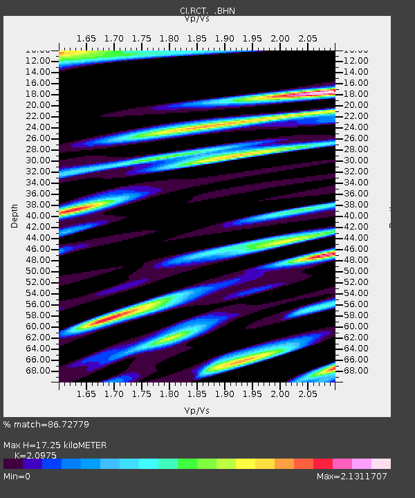
| Estimated Moho Depth: |
17.25 km |
| Estimated Crust Vp/Vs: |
2.10 |
| Assumed Crust Vp: |
6.291 km/s |
| Estimated Crust Vs: |
2.999 km/s |
| Estimated Crust Poisson's Ratio: |
0.35 |
|
| Radial Match: |
86.72779 % |
| Radial Bump: |
400 |
| Transverse Match: |
79.30334 % |
| Transverse Bump: |
400 |
| SOD ConfigId: |
2564 |
| Insert Time: |
2010-03-05 22:13:35.344 +0000 |
| GWidth: |
2.5 |
| Max Bumps: |
400 |
| Tol: |
0.001 |
|
Signal To Noise
| Channel | StoN | STA | LTA |
| CI:RCT: :BHN:20060817T11:20:31.297019Z | 5.887738 | 9.173346E-7 | 1.5580424E-7 |
| CI:RCT: :BHE:20060817T11:20:31.297019Z | 4.526589 | 8.192602E-7 | 1.8098842E-7 |
| CI:RCT: :BHZ:20060817T11:20:31.297019Z | 23.225002 | 1.9947527E-6 | 8.588815E-8 |
| Arrivals |
| Ps | 3.1 SECOND |
| PpPs | 8.1 SECOND |
| PsPs/PpSs | 11 SECOND |


