You are here: Home > Network List > CI - Caltech Regional Seismic Network Stations List
> Station RCT Rector, Visalia, CA, USA > Earthquake Result Viewer
RCT Rector, Visalia, CA, USA - Earthquake Result Viewer
| Earthquake location: |
Fox Islands, Aleutian Islands |
| Earthquake latitude/longitude: |
54.0/-166.4 |
| Earthquake time(UTC): |
2006/09/01 (244) 12:04:22 GMT |
| Earthquake Depth: |
76 km |
| Earthquake Magnitude: |
5.8 MB, 5.9 MW |
| Earthquake Catalog/Contributor: |
WHDF/NEIC |
|
| Network: |
CI Caltech Regional Seismic Network |
| Station: |
RCT Rector, Visalia, CA, USA |
| Lat/Lon: |
36.31 N/119.24 W |
| Elevation: |
107 m |
|
| Distance: |
36.9 deg |
| Az: |
99.111 deg |
| Baz: |
313.767 deg |
| Ray Param: |
0.07623051 |
| Estimated Moho Depth: |
21.75 km |
| Estimated Crust Vp/Vs: |
2.03 |
| Assumed Crust Vp: |
6.291 km/s |
| Estimated Crust Vs: |
3.095 km/s |
| Estimated Crust Poisson's Ratio: |
0.34 |
|
| Radial Match: |
91.88868 % |
| Radial Bump: |
400 |
| Transverse Match: |
88.03314 % |
| Transverse Bump: |
400 |
| SOD ConfigId: |
2665 |
| Insert Time: |
2010-03-05 22:13:39.079 +0000 |
| GWidth: |
2.5 |
| Max Bumps: |
400 |
| Tol: |
0.001 |
|
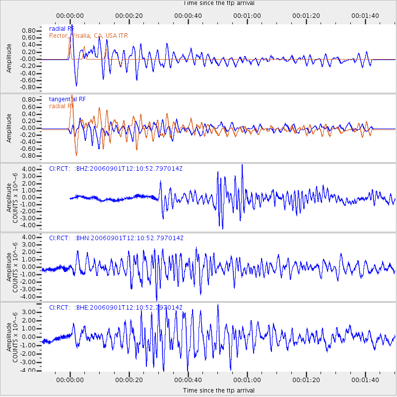
Signal To Noise
| Channel | StoN | STA | LTA |
| CI:RCT: :BHN:20060901T12:10:52.797014Z | 4.2321777 | 8.631549E-7 | 2.0395053E-7 |
| CI:RCT: :BHE:20060901T12:10:52.797014Z | 3.2478564 | 8.1081777E-7 | 2.4964703E-7 |
| CI:RCT: :BHZ:20060901T12:10:52.797014Z | 5.5564733 | 1.2750572E-6 | 2.294724E-7 |
| Arrivals |
| Ps | 3.8 SECOND |
| PpPs | 9.9 SECOND |
| PsPs/PpSs | 14 SECOND |


