You are here: Home > Network List > CI - Caltech Regional Seismic Network Stations List
> Station RCT Rector, Visalia, CA, USA > Earthquake Result Viewer
RCT Rector, Visalia, CA, USA - Earthquake Result Viewer
| Earthquake location: |
Bonin Islands, Japan Region |
| Earthquake latitude/longitude: |
26.1/144.0 |
| Earthquake time(UTC): |
2006/08/06 (218) 18:16:40 GMT |
| Earthquake Depth: |
23 km |
| Earthquake Magnitude: |
6.0 MB, 5.6 MS, 5.8 MW, 5.8 MW |
| Earthquake Catalog/Contributor: |
WHDF/NEIC |
|
| Network: |
CI Caltech Regional Seismic Network |
| Station: |
RCT Rector, Visalia, CA, USA |
| Lat/Lon: |
36.31 N/119.24 W |
| Elevation: |
107 m |
|
| Distance: |
80.0 deg |
| Az: |
54.53 deg |
| Baz: |
294.982 deg |
| Ray Param: |
0.0485174 |
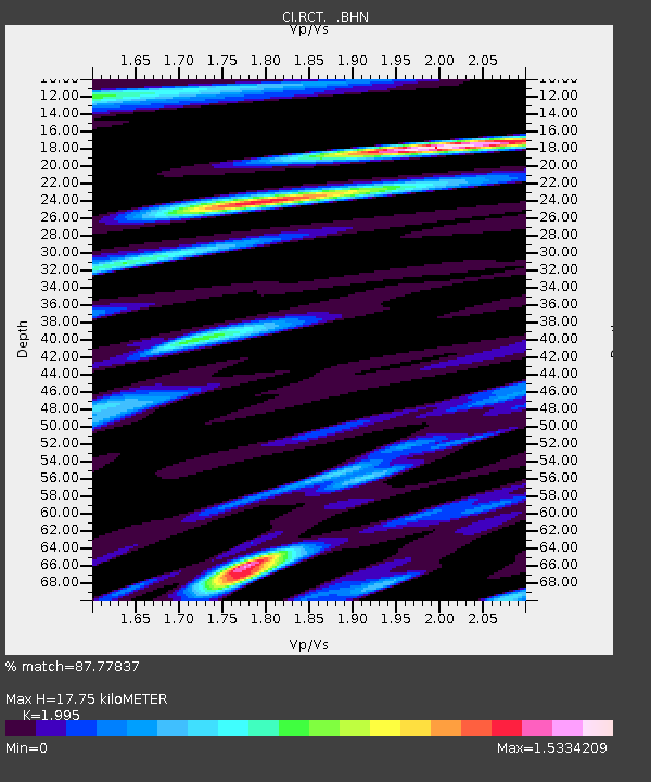
| Estimated Moho Depth: |
17.75 km |
| Estimated Crust Vp/Vs: |
2.00 |
| Assumed Crust Vp: |
6.291 km/s |
| Estimated Crust Vs: |
3.154 km/s |
| Estimated Crust Poisson's Ratio: |
0.33 |
|
| Radial Match: |
87.77837 % |
| Radial Bump: |
400 |
| Transverse Match: |
81.286255 % |
| Transverse Bump: |
400 |
| SOD ConfigId: |
2665 |
| Insert Time: |
2010-03-05 22:13:40.524 +0000 |
| GWidth: |
2.5 |
| Max Bumps: |
400 |
| Tol: |
0.001 |
|
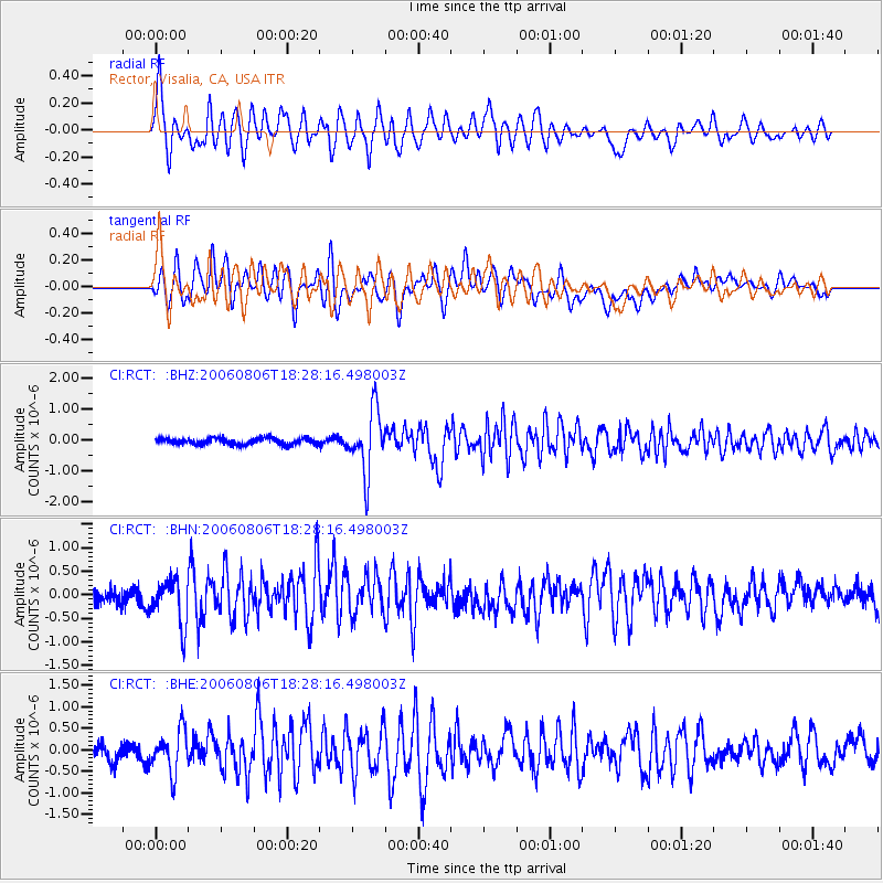
Signal To Noise
| Channel | StoN | STA | LTA |
| CI:RCT: :BHN:20060806T18:28:16.498003Z | 2.948556 | 4.799891E-7 | 1.6278786E-7 |
| CI:RCT: :BHE:20060806T18:28:16.498003Z | 3.1797113 | 4.8504984E-7 | 1.5254524E-7 |
| CI:RCT: :BHZ:20060806T18:28:16.498003Z | 9.984205 | 1.0060509E-6 | 1.00764254E-7 |
| Arrivals |
| Ps | 2.9 SECOND |
| PpPs | 8.2 SECOND |
| PsPs/PpSs | 11 SECOND |


