You are here: Home > Network List > CI - Caltech Regional Seismic Network Stations List
> Station RCT Rector, Visalia, CA, USA > Earthquake Result Viewer
RCT Rector, Visalia, CA, USA - Earthquake Result Viewer
| Earthquake location: |
Off East Coast Of Honshu, Japan |
| Earthquake latitude/longitude: |
36.5/142.4 |
| Earthquake time(UTC): |
2008/12/20 (355) 10:29:23 GMT |
| Earthquake Depth: |
19 km |
| Earthquake Magnitude: |
6.0 MB, 6.3 MS, 6.3 MW, 6.3 MW |
| Earthquake Catalog/Contributor: |
WHDF/NEIC |
|
| Network: |
CI Caltech Regional Seismic Network |
| Station: |
RCT Rector, Visalia, CA, USA |
| Lat/Lon: |
36.31 N/119.24 W |
| Elevation: |
107 m |
|
| Distance: |
75.2 deg |
| Az: |
55.753 deg |
| Baz: |
304.5 deg |
| Ray Param: |
0.051802035 |
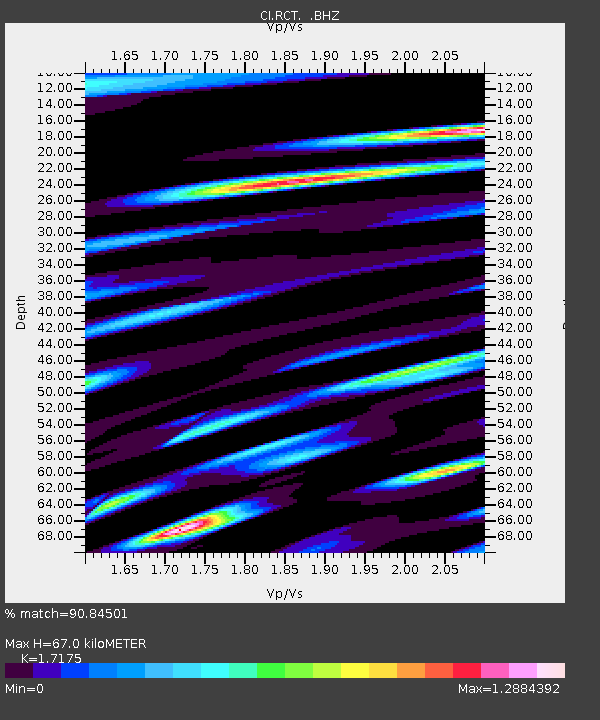
| Estimated Moho Depth: |
67.0 km |
| Estimated Crust Vp/Vs: |
1.72 |
| Assumed Crust Vp: |
6.291 km/s |
| Estimated Crust Vs: |
3.663 km/s |
| Estimated Crust Poisson's Ratio: |
0.24 |
|
| Radial Match: |
90.84501 % |
| Radial Bump: |
385 |
| Transverse Match: |
79.26319 % |
| Transverse Bump: |
400 |
| SOD ConfigId: |
2658 |
| Insert Time: |
2010-03-05 22:13:54.704 +0000 |
| GWidth: |
2.5 |
| Max Bumps: |
400 |
| Tol: |
0.001 |
|
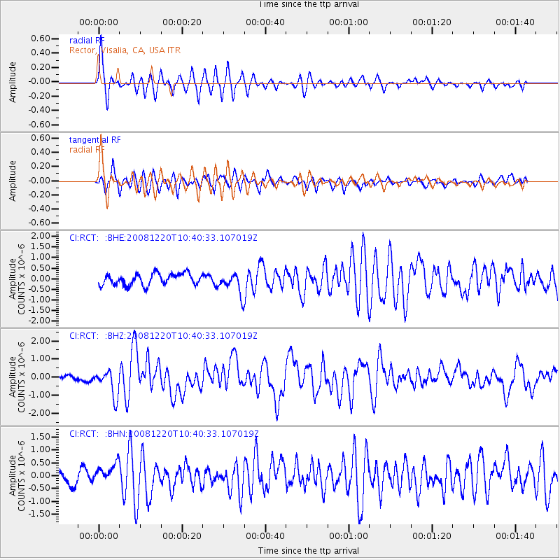
Signal To Noise
| Channel | StoN | STA | LTA |
| CI:RCT: :BHZ:20081220T10:40:33.107019Z | 4.490518 | 7.608145E-7 | 1.6942688E-7 |
| CI:RCT: :BHN:20081220T10:40:33.107019Z | 2.0165858 | 4.1359496E-7 | 2.0509663E-7 |
| CI:RCT: :BHE:20081220T10:40:33.107019Z | 1.9943389 | 5.3542993E-7 | 2.684749E-7 |
| Arrivals |
| Ps | 7.9 SECOND |
| PpPs | 28 SECOND |
| PsPs/PpSs | 36 SECOND |


