You are here: Home > Network List > CI - Caltech Regional Seismic Network Stations List
> Station RCT Rector, Visalia, CA, USA > Earthquake Result Viewer
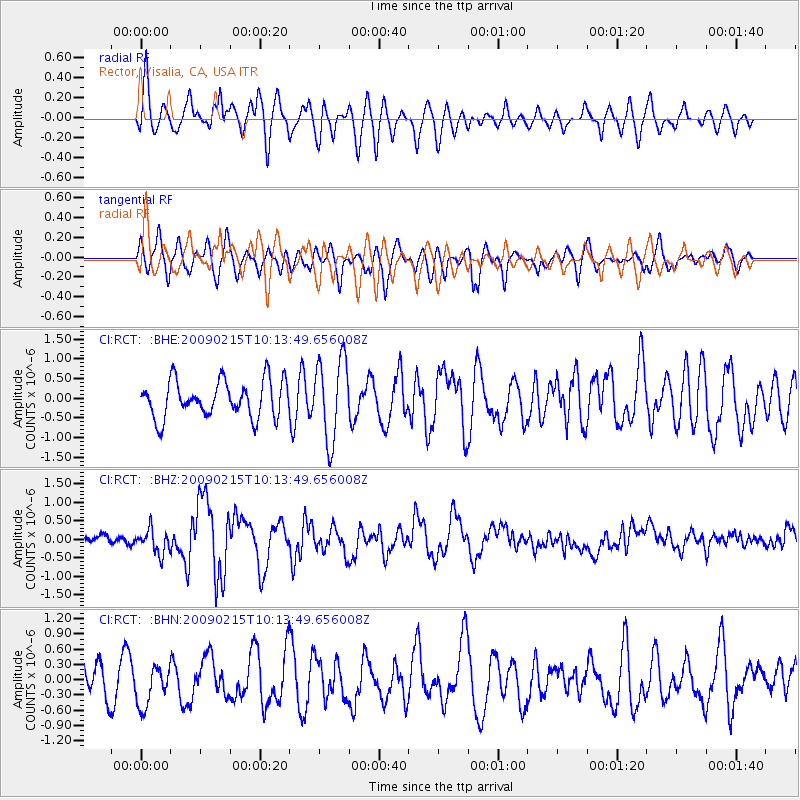
RCT Rector, Visalia, CA, USA - Earthquake Result Viewer
*The percent match for this event was below the threshold and hence no stack was calculated.
| Earthquake location: |
Near Coast Of Northern Peru |
| Earthquake latitude/longitude: |
-5.9/-80.9 |
| Earthquake time(UTC): |
2009/02/15 (046) 10:04:49 GMT |
| Earthquake Depth: |
21 km |
| Earthquake Magnitude: |
5.8 MB, 5.7 MS, 6.1 MW, 6.1 MW |
| Earthquake Catalog/Contributor: |
WHDF/NEIC |
|
| Network: |
CI Caltech Regional Seismic Network |
| Station: |
RCT Rector, Visalia, CA, USA |
| Lat/Lon: |
36.31 N/119.24 W |
| Elevation: |
107 m |
|
| Distance: |
55.2 deg |
| Az: |
322.392 deg |
| Baz: |
131.27 deg |
| Ray Param: |
$rayparam |
*The percent match for this event was below the threshold and hence was not used in the summary stack. |
|
| Radial Match: |
62.594334 % |
| Radial Bump: |
400 |
| Transverse Match: |
57.91719 % |
| Transverse Bump: |
400 |
| SOD ConfigId: |
2658 |
| Insert Time: |
2010-03-05 22:14:09.615 +0000 |
| GWidth: |
2.5 |
| Max Bumps: |
400 |
| Tol: |
0.001 |
|
Signal To Noise
| Channel | StoN | STA | LTA |
| CI:RCT: :BHZ:20090215T10:13:49.656008Z | 1.9461862 | 3.3236782E-7 | 1.7077905E-7 |
| CI:RCT: :BHN:20090215T10:13:49.656008Z | 1.3226514 | 3.942269E-7 | 2.9805807E-7 |
| CI:RCT: :BHE:20090215T10:13:49.656008Z | 2.2129173 | 1.0278449E-6 | 4.6447502E-7 |
| Arrivals |
| Ps | |
| PpPs | |
| PsPs/PpSs | |


