You are here: Home > Network List > TA - USArray Transportable Network (new EarthScope stations) Stations List
> Station M31M Drury Creek, Yukon, CA > Earthquake Result Viewer
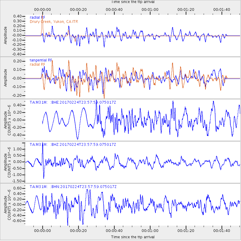
M31M Drury Creek, Yukon, CA - Earthquake Result Viewer
*The percent match for this event was below the threshold and hence no stack was calculated.
| Earthquake location: |
Fiji Islands Region |
| Earthquake latitude/longitude: |
-18.0/-178.5 |
| Earthquake time(UTC): |
2017/02/24 (055) 23:46:45 GMT |
| Earthquake Depth: |
581 km |
| Earthquake Magnitude: |
5.9 Mww |
| Earthquake Catalog/Contributor: |
NEIC PDE/us |
|
| Network: |
TA USArray Transportable Network (new EarthScope stations) |
| Station: |
M31M Drury Creek, Yukon, CA |
| Lat/Lon: |
62.20 N/134.39 W |
| Elevation: |
639 m |
|
| Distance: |
87.1 deg |
| Az: |
19.052 deg |
| Baz: |
221.512 deg |
| Ray Param: |
$rayparam |
*The percent match for this event was below the threshold and hence was not used in the summary stack. |
|
| Radial Match: |
49.756065 % |
| Radial Bump: |
400 |
| Transverse Match: |
47.191574 % |
| Transverse Bump: |
400 |
| SOD ConfigId: |
11737051 |
| Insert Time: |
2019-04-26 20:11:22.506 +0000 |
| GWidth: |
2.5 |
| Max Bumps: |
400 |
| Tol: |
0.001 |
|
Signal To Noise
| Channel | StoN | STA | LTA |
| TA:M31M: :BHZ:20170224T23:57:59.075017Z | 2.7916405 | 5.12606E-7 | 1.8362178E-7 |
| TA:M31M: :BHN:20170224T23:57:59.075017Z | 1.3696191 | 1.8877283E-7 | 1.378287E-7 |
| TA:M31M: :BHE:20170224T23:57:59.075017Z | 1.3171365 | 2.6459023E-7 | 2.0088291E-7 |
| Arrivals |
| Ps | |
| PpPs | |
| PsPs/PpSs | |


