You are here: Home > Network List > CI - Caltech Regional Seismic Network Stations List
> Station RCT Rector, Visalia, CA, USA > Earthquake Result Viewer
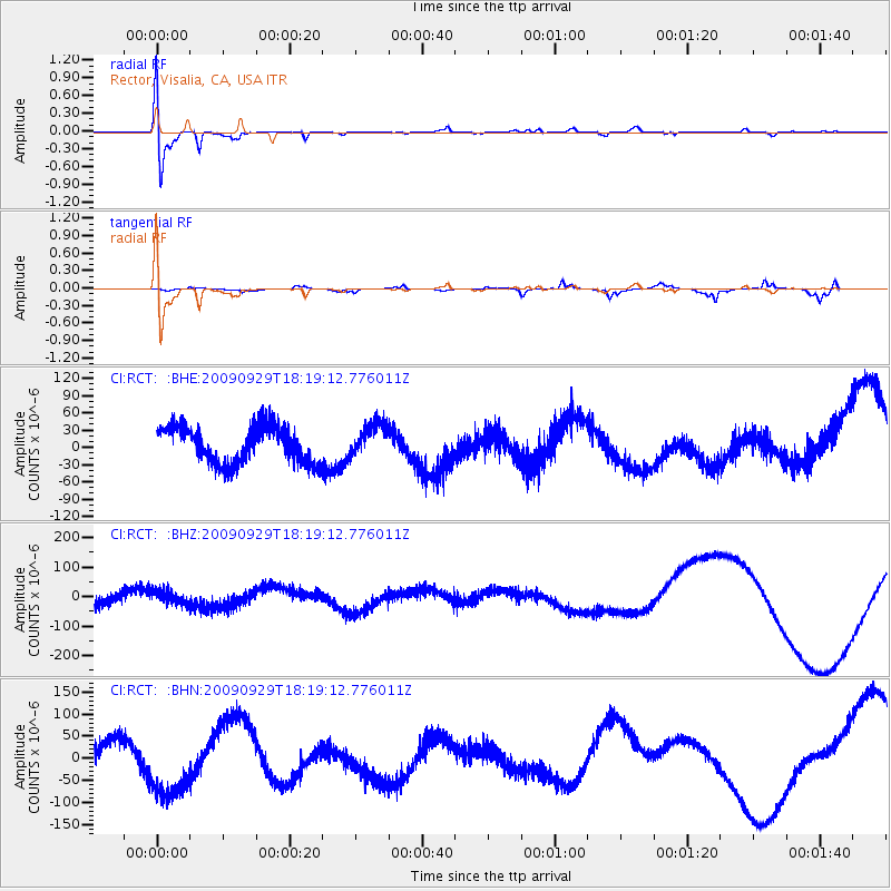
RCT Rector, Visalia, CA, USA - Earthquake Result Viewer
*The percent match for this event was below the threshold and hence no stack was calculated.
| Earthquake location: |
Samoa Islands Region |
| Earthquake latitude/longitude: |
-15.6/-172.0 |
| Earthquake time(UTC): |
2009/09/29 (272) 18:08:21 GMT |
| Earthquake Depth: |
10 km |
| Earthquake Magnitude: |
5.6 MB |
| Earthquake Catalog/Contributor: |
WHDF/NEIC |
|
| Network: |
CI Caltech Regional Seismic Network |
| Station: |
RCT Rector, Visalia, CA, USA |
| Lat/Lon: |
36.31 N/119.24 W |
| Elevation: |
107 m |
|
| Distance: |
71.7 deg |
| Az: |
42.641 deg |
| Baz: |
233.928 deg |
| Ray Param: |
$rayparam |
*The percent match for this event was below the threshold and hence was not used in the summary stack. |
|
| Radial Match: |
64.458305 % |
| Radial Bump: |
400 |
| Transverse Match: |
56.854794 % |
| Transverse Bump: |
338 |
| SOD ConfigId: |
2622 |
| Insert Time: |
2010-03-05 22:14:29.828 +0000 |
| GWidth: |
2.5 |
| Max Bumps: |
400 |
| Tol: |
0.001 |
|
Signal To Noise
| Channel | StoN | STA | LTA |
| CI:RCT: :BHZ:20090929T18:19:12.776011Z | 1.5012472 | 2.2789101E-5 | 1.5180113E-5 |
| CI:RCT: :BHN:20090929T18:19:12.776011Z | 2.5567932 | 7.082103E-5 | 2.7699163E-5 |
| CI:RCT: :BHE:20090929T18:19:12.776011Z | 0.9249087 | 2.9087323E-5 | 3.144886E-5 |
| Arrivals |
| Ps | |
| PpPs | |
| PsPs/PpSs | |


