You are here: Home > Network List > CI - Caltech Regional Seismic Network Stations List
> Station RCT Rector, Visalia, CA, USA > Earthquake Result Viewer
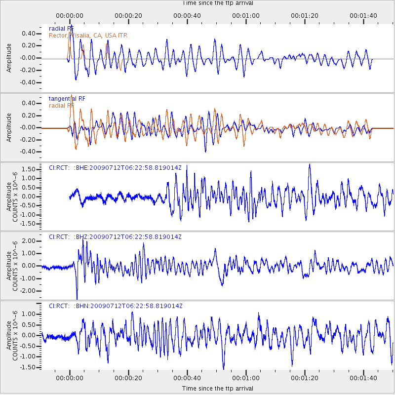
RCT Rector, Visalia, CA, USA - Earthquake Result Viewer
*The percent match for this event was below the threshold and hence no stack was calculated.
| Earthquake location: |
Southern Peru |
| Earthquake latitude/longitude: |
-15.0/-70.4 |
| Earthquake time(UTC): |
2009/07/12 (193) 06:12:47 GMT |
| Earthquake Depth: |
199 km |
| Earthquake Magnitude: |
5.7 MB, 6.1 MW, 6.1 MW |
| Earthquake Catalog/Contributor: |
WHDF/NEIC |
|
| Network: |
CI Caltech Regional Seismic Network |
| Station: |
RCT Rector, Visalia, CA, USA |
| Lat/Lon: |
36.31 N/119.24 W |
| Elevation: |
107 m |
|
| Distance: |
68.8 deg |
| Az: |
319.308 deg |
| Baz: |
128.752 deg |
| Ray Param: |
$rayparam |
*The percent match for this event was below the threshold and hence was not used in the summary stack. |
|
| Radial Match: |
77.70397 % |
| Radial Bump: |
400 |
| Transverse Match: |
64.434814 % |
| Transverse Bump: |
400 |
| SOD ConfigId: |
2648 |
| Insert Time: |
2010-03-05 22:14:45.669 +0000 |
| GWidth: |
2.5 |
| Max Bumps: |
400 |
| Tol: |
0.001 |
|
Signal To Noise
| Channel | StoN | STA | LTA |
| CI:RCT: :BHZ:20090712T06:22:58.819014Z | 10.928105 | 9.225277E-7 | 8.44179E-8 |
| CI:RCT: :BHN:20090712T06:22:58.819014Z | 2.560698 | 3.3567767E-7 | 1.3108834E-7 |
| CI:RCT: :BHE:20090712T06:22:58.819014Z | 2.4671025 | 4.1767018E-7 | 1.6929584E-7 |
| Arrivals |
| Ps | |
| PpPs | |
| PsPs/PpSs | |


