You are here: Home > Network List > UW - Pacific Northwest Regional Seismic Network Stations List
> Station MRBL Marblemount, WA, USA > Earthquake Result Viewer
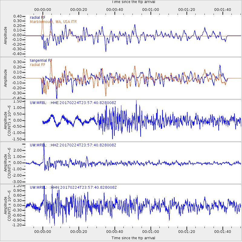
MRBL Marblemount, WA, USA - Earthquake Result Viewer
*The percent match for this event was below the threshold and hence no stack was calculated.
| Earthquake location: |
Fiji Islands Region |
| Earthquake latitude/longitude: |
-18.0/-178.5 |
| Earthquake time(UTC): |
2017/02/24 (055) 23:46:45 GMT |
| Earthquake Depth: |
581 km |
| Earthquake Magnitude: |
5.9 Mww |
| Earthquake Catalog/Contributor: |
NEIC PDE/us |
|
| Network: |
UW Pacific Northwest Regional Seismic Network |
| Station: |
MRBL Marblemount, WA, USA |
| Lat/Lon: |
48.52 N/121.48 W |
| Elevation: |
75 m |
|
| Distance: |
83.3 deg |
| Az: |
34.139 deg |
| Baz: |
233.457 deg |
| Ray Param: |
$rayparam |
*The percent match for this event was below the threshold and hence was not used in the summary stack. |
|
| Radial Match: |
73.298416 % |
| Radial Bump: |
400 |
| Transverse Match: |
67.434875 % |
| Transverse Bump: |
400 |
| SOD ConfigId: |
11737051 |
| Insert Time: |
2019-04-26 20:13:05.741 +0000 |
| GWidth: |
2.5 |
| Max Bumps: |
400 |
| Tol: |
0.001 |
|
Signal To Noise
| Channel | StoN | STA | LTA |
| UW:MRBL: :HHZ:20170224T23:57:40.828008Z | 4.245209 | 8.617135E-7 | 2.0298492E-7 |
| UW:MRBL: :HHN:20170224T23:57:40.828008Z | 2.4291878 | 3.8041915E-7 | 1.5660343E-7 |
| UW:MRBL: :HHE:20170224T23:57:40.828008Z | 1.7629778 | 3.9959627E-7 | 2.2665982E-7 |
| Arrivals |
| Ps | |
| PpPs | |
| PsPs/PpSs | |


