You are here: Home > Network List > CI - Caltech Regional Seismic Network Stations List
> Station RCT Rector, Visalia, CA, USA > Earthquake Result Viewer
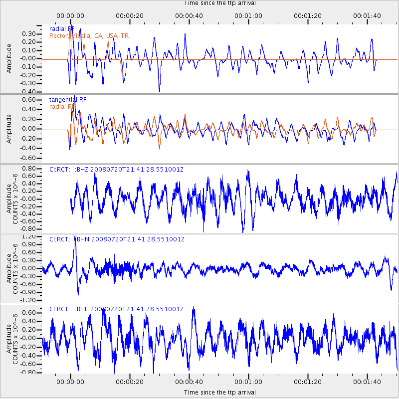
RCT Rector, Visalia, CA, USA - Earthquake Result Viewer
*The percent match for this event was below the threshold and hence no stack was calculated.
| Earthquake location: |
Bonin Islands, Japan Region |
| Earthquake latitude/longitude: |
27.8/139.6 |
| Earthquake time(UTC): |
2008/07/20 (202) 21:30:29 GMT |
| Earthquake Depth: |
481 km |
| Earthquake Magnitude: |
5.8 MW, 5.1 MB, 5.8 MW |
| Earthquake Catalog/Contributor: |
WHDF/NEIC |
|
| Network: |
CI Caltech Regional Seismic Network |
| Station: |
RCT Rector, Visalia, CA, USA |
| Lat/Lon: |
36.31 N/119.24 W |
| Elevation: |
107 m |
|
| Distance: |
82.2 deg |
| Az: |
53.117 deg |
| Baz: |
298.668 deg |
| Ray Param: |
$rayparam |
*The percent match for this event was below the threshold and hence was not used in the summary stack. |
|
| Radial Match: |
47.495586 % |
| Radial Bump: |
400 |
| Transverse Match: |
68.31968 % |
| Transverse Bump: |
400 |
| SOD ConfigId: |
2504 |
| Insert Time: |
2010-03-05 22:14:54.341 +0000 |
| GWidth: |
2.5 |
| Max Bumps: |
400 |
| Tol: |
0.001 |
|
Signal To Noise
| Channel | StoN | STA | LTA |
| CI:RCT: :BHN:20080720T21:41:28.551001Z | 4.3844028 | 5.0072657E-7 | 1.1420633E-7 |
| CI:RCT: :BHE:20080720T21:41:28.551001Z | 1.3487386 | 2.9476152E-7 | 2.1854608E-7 |
| CI:RCT: :BHZ:20080720T21:41:28.551001Z | 1.0469682 | 2.7174417E-7 | 2.5955342E-7 |
| Arrivals |
| Ps | |
| PpPs | |
| PsPs/PpSs | |


