You are here: Home > Network List > CI - Caltech Regional Seismic Network Stations List
> Station RCT Rector, Visalia, CA, USA > Earthquake Result Viewer
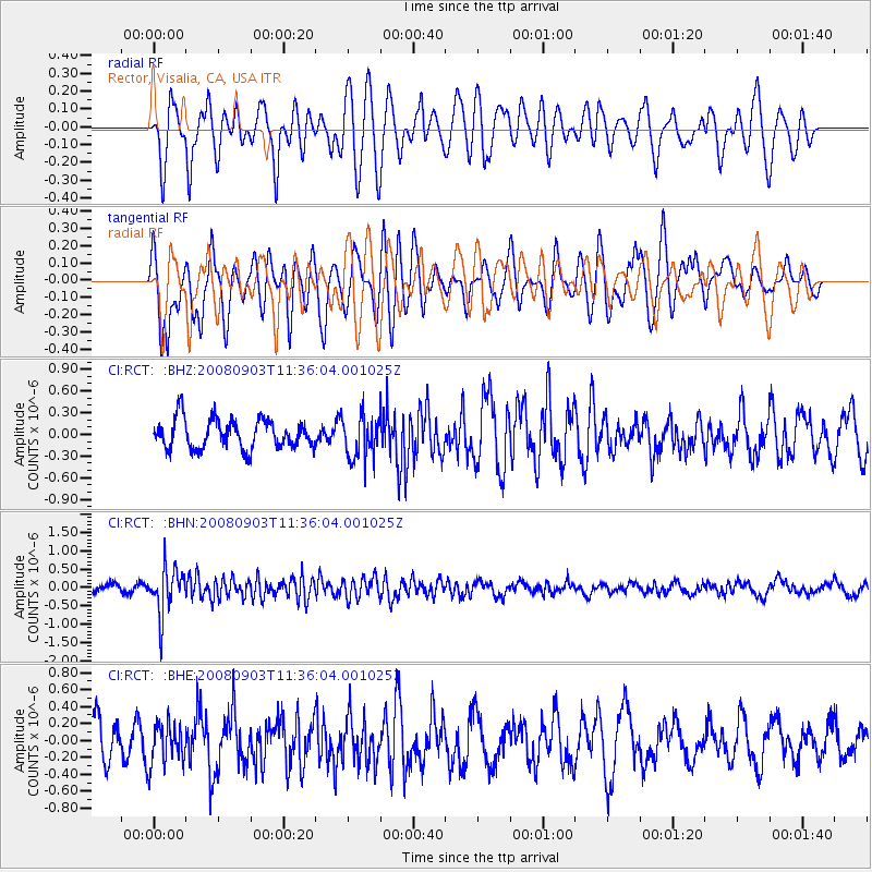
RCT Rector, Visalia, CA, USA - Earthquake Result Viewer
*The percent match for this event was below the threshold and hence no stack was calculated.
| Earthquake location: |
Santiago Del Estero Prov., Arg. |
| Earthquake latitude/longitude: |
-26.7/-63.2 |
| Earthquake time(UTC): |
2008/09/03 (247) 11:25:14 GMT |
| Earthquake Depth: |
570 km |
| Earthquake Magnitude: |
5.9 MB, 6.3 MW, 6.3 MW |
| Earthquake Catalog/Contributor: |
WHDF/NEIC |
|
| Network: |
CI Caltech Regional Seismic Network |
| Station: |
RCT Rector, Visalia, CA, USA |
| Lat/Lon: |
36.31 N/119.24 W |
| Elevation: |
107 m |
|
| Distance: |
82.0 deg |
| Az: |
317.431 deg |
| Baz: |
131.501 deg |
| Ray Param: |
$rayparam |
*The percent match for this event was below the threshold and hence was not used in the summary stack. |
|
| Radial Match: |
52.244366 % |
| Radial Bump: |
400 |
| Transverse Match: |
65.0324 % |
| Transverse Bump: |
400 |
| SOD ConfigId: |
2504 |
| Insert Time: |
2010-03-05 22:14:56.783 +0000 |
| GWidth: |
2.5 |
| Max Bumps: |
400 |
| Tol: |
0.001 |
|
Signal To Noise
| Channel | StoN | STA | LTA |
| CI:RCT: :BHN:20080903T11:36:04.001025Z | 3.9767492 | 6.246145E-7 | 1.5706661E-7 |
| CI:RCT: :BHE:20080903T11:36:04.001025Z | 0.84267455 | 2.3611982E-7 | 2.8020287E-7 |
| CI:RCT: :BHZ:20080903T11:36:04.001025Z | 1.4823211 | 2.984472E-7 | 2.0133774E-7 |
| Arrivals |
| Ps | |
| PpPs | |
| PsPs/PpSs | |


