You are here: Home > Network List > II - Global Seismograph Network (GSN - IRIS/IDA) Stations List
> Station NIL Nilore, Pakistan > Earthquake Result Viewer
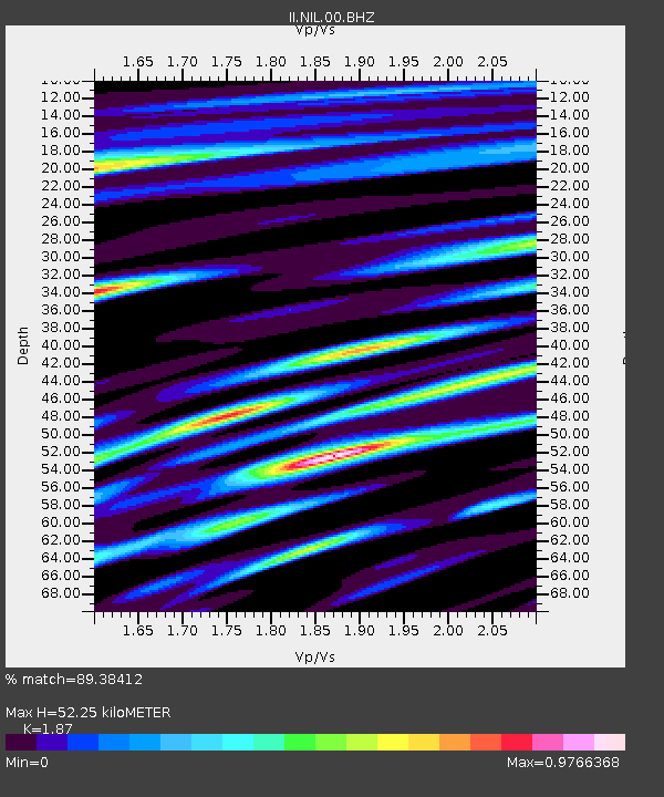
NIL Nilore, Pakistan - Earthquake Result Viewer
| Earthquake location: |
Northwest Of Ryukyu Islands |
| Earthquake latitude/longitude: |
31.1/128.8 |
| Earthquake time(UTC): |
2015/11/13 (317) 20:51:32 GMT |
| Earthquake Depth: |
10 km |
| Earthquake Magnitude: |
6.5 MWB |
| Earthquake Catalog/Contributor: |
NEIC PDE/NEIC COMCAT |
|
| Network: |
II Global Seismograph Network (GSN - IRIS/IDA) |
| Station: |
NIL Nilore, Pakistan |
| Lat/Lon: |
33.65 N/73.27 E |
| Elevation: |
629 m |
|
| Distance: |
46.5 deg |
| Az: |
288.569 deg |
| Baz: |
77.225 deg |
| Ray Param: |
0.07059404 |
| Estimated Moho Depth: |
52.25 km |
| Estimated Crust Vp/Vs: |
1.87 |
| Assumed Crust Vp: |
6.242 km/s |
| Estimated Crust Vs: |
3.338 km/s |
| Estimated Crust Poisson's Ratio: |
0.30 |
|
| Radial Match: |
89.38412 % |
| Radial Bump: |
400 |
| Transverse Match: |
85.44579 % |
| Transverse Bump: |
360 |
| SOD ConfigId: |
1259291 |
| Insert Time: |
2015-11-27 21:09:39.346 +0000 |
| GWidth: |
2.5 |
| Max Bumps: |
400 |
| Tol: |
0.001 |
|

Signal To Noise
| Channel | StoN | STA | LTA |
| II:NIL:00:BHZ:20151113T20:59:28.969011Z | 2.3450866 | 2.2435435E-7 | 9.566996E-8 |
| II:NIL:00:BH1:20151113T20:59:28.969011Z | 0.8605878 | 8.1237545E-8 | 9.439775E-8 |
| II:NIL:00:BH2:20151113T20:59:28.969011Z | 0.6398082 | 5.5762335E-8 | 8.7154774E-8 |
| Arrivals |
| Ps | 7.7 SECOND |
| PpPs | 23 SECOND |
| PsPs/PpSs | 30 SECOND |


