You are here: Home > Network List > TA - USArray Transportable Network (new EarthScope stations) Stations List
> Station F21K Alatna River, AK, USA > Earthquake Result Viewer
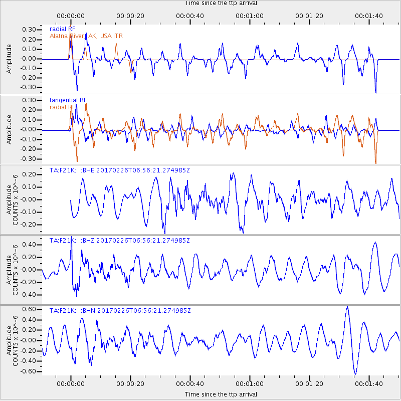
F21K Alatna River, AK, USA - Earthquake Result Viewer
*The percent match for this event was below the threshold and hence no stack was calculated.
| Earthquake location: |
Vanuatu Islands |
| Earthquake latitude/longitude: |
-18.5/169.4 |
| Earthquake time(UTC): |
2017/02/26 (057) 06:44:21 GMT |
| Earthquake Depth: |
244 km |
| Earthquake Magnitude: |
5.5 mb |
| Earthquake Catalog/Contributor: |
NEIC PDE/us |
|
| Network: |
TA USArray Transportable Network (new EarthScope stations) |
| Station: |
F21K Alatna River, AK, USA |
| Lat/Lon: |
67.22 N/153.48 W |
| Elevation: |
597 m |
|
| Distance: |
89.8 deg |
| Az: |
13.596 deg |
| Baz: |
214.949 deg |
| Ray Param: |
$rayparam |
*The percent match for this event was below the threshold and hence was not used in the summary stack. |
|
| Radial Match: |
47.170338 % |
| Radial Bump: |
362 |
| Transverse Match: |
56.710987 % |
| Transverse Bump: |
400 |
| SOD ConfigId: |
11737051 |
| Insert Time: |
2019-04-26 20:19:07.357 +0000 |
| GWidth: |
2.5 |
| Max Bumps: |
400 |
| Tol: |
0.001 |
|
Signal To Noise
| Channel | StoN | STA | LTA |
| TA:F21K: :BHZ:20170226T06:56:21.274985Z | 1.842229 | 2.485795E-7 | 1.349341E-7 |
| TA:F21K: :BHN:20170226T06:56:21.274985Z | 1.9658027 | 2.84716E-7 | 1.4483447E-7 |
| TA:F21K: :BHE:20170226T06:56:21.274985Z | 1.5702899 | 1.3044252E-7 | 8.306907E-8 |
| Arrivals |
| Ps | |
| PpPs | |
| PsPs/PpSs | |


