You are here: Home > Network List > TA - USArray Transportable Network (new EarthScope stations) Stations List
> Station O17K Koliganek, Bristol Bay, AK, USA > Earthquake Result Viewer
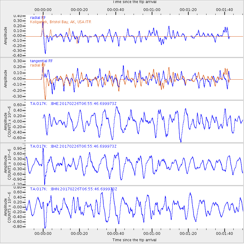
O17K Koliganek, Bristol Bay, AK, USA - Earthquake Result Viewer
*The percent match for this event was below the threshold and hence no stack was calculated.
| Earthquake location: |
Vanuatu Islands |
| Earthquake latitude/longitude: |
-18.5/169.4 |
| Earthquake time(UTC): |
2017/02/26 (057) 06:44:21 GMT |
| Earthquake Depth: |
244 km |
| Earthquake Magnitude: |
5.5 mb |
| Earthquake Catalog/Contributor: |
NEIC PDE/us |
|
| Network: |
TA USArray Transportable Network (new EarthScope stations) |
| Station: |
O17K Koliganek, Bristol Bay, AK, USA |
| Lat/Lon: |
59.77 N/157.09 W |
| Elevation: |
156 m |
|
| Distance: |
82.7 deg |
| Az: |
16.365 deg |
| Baz: |
211.897 deg |
| Ray Param: |
$rayparam |
*The percent match for this event was below the threshold and hence was not used in the summary stack. |
|
| Radial Match: |
45.08781 % |
| Radial Bump: |
400 |
| Transverse Match: |
63.21275 % |
| Transverse Bump: |
400 |
| SOD ConfigId: |
11737051 |
| Insert Time: |
2019-04-26 20:19:19.160 +0000 |
| GWidth: |
2.5 |
| Max Bumps: |
400 |
| Tol: |
0.001 |
|
Signal To Noise
| Channel | StoN | STA | LTA |
| TA:O17K: :BHZ:20170226T06:55:46.699973Z | 2.1694827 | 5.1249623E-7 | 2.3622967E-7 |
| TA:O17K: :BHN:20170226T06:55:46.699973Z | 1.4961358 | 3.796016E-7 | 2.5372134E-7 |
| TA:O17K: :BHE:20170226T06:55:46.699973Z | 1.6540934 | 3.201418E-7 | 1.9354518E-7 |
| Arrivals |
| Ps | |
| PpPs | |
| PsPs/PpSs | |


