You are here: Home > Network List > UW - Pacific Northwest Regional Seismic Network Stations List
> Station MRBL Marblemount, WA, USA > Earthquake Result Viewer
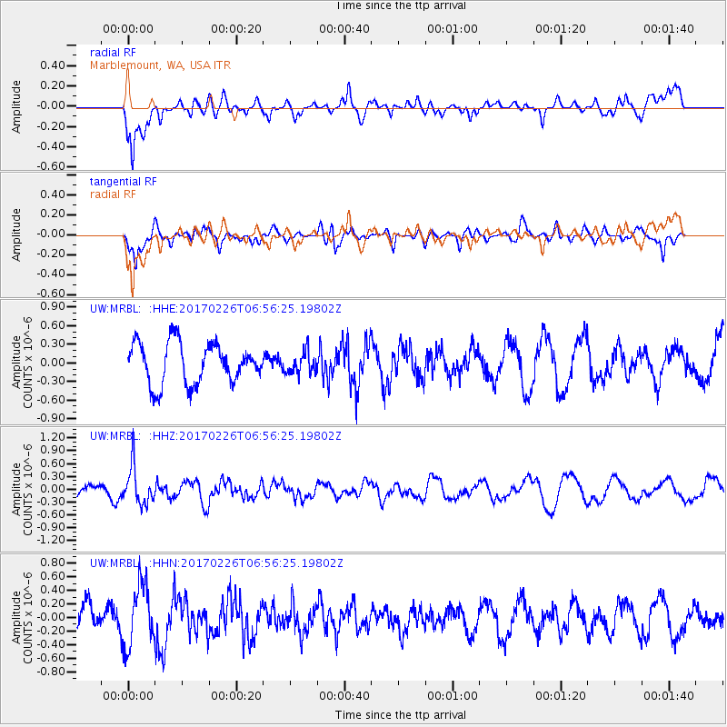
MRBL Marblemount, WA, USA - Earthquake Result Viewer
*The percent match for this event was below the threshold and hence no stack was calculated.
| Earthquake location: |
Vanuatu Islands |
| Earthquake latitude/longitude: |
-18.5/169.4 |
| Earthquake time(UTC): |
2017/02/26 (057) 06:44:21 GMT |
| Earthquake Depth: |
244 km |
| Earthquake Magnitude: |
5.5 mb |
| Earthquake Catalog/Contributor: |
NEIC PDE/us |
|
| Network: |
UW Pacific Northwest Regional Seismic Network |
| Station: |
MRBL Marblemount, WA, USA |
| Lat/Lon: |
48.52 N/121.48 W |
| Elevation: |
75 m |
|
| Distance: |
90.6 deg |
| Az: |
38.412 deg |
| Baz: |
242.458 deg |
| Ray Param: |
$rayparam |
*The percent match for this event was below the threshold and hence was not used in the summary stack. |
|
| Radial Match: |
67.549 % |
| Radial Bump: |
400 |
| Transverse Match: |
72.70445 % |
| Transverse Bump: |
400 |
| SOD ConfigId: |
11737051 |
| Insert Time: |
2019-04-26 20:20:17.965 +0000 |
| GWidth: |
2.5 |
| Max Bumps: |
400 |
| Tol: |
0.001 |
|
Signal To Noise
| Channel | StoN | STA | LTA |
| UW:MRBL: :HHZ:20170226T06:56:25.19802Z | 1.3131478 | 4.462302E-7 | 3.398172E-7 |
| UW:MRBL: :HHN:20170226T06:56:25.19802Z | 1.8443068 | 4.5496597E-7 | 2.466867E-7 |
| UW:MRBL: :HHE:20170226T06:56:25.19802Z | 0.52644014 | 1.726835E-7 | 3.2802117E-7 |
| Arrivals |
| Ps | |
| PpPs | |
| PsPs/PpSs | |


