You are here: Home > Network List > CI - Caltech Regional Seismic Network Stations List
> Station VTV Victorville, California, USA > Earthquake Result Viewer
VTV Victorville, California, USA - Earthquake Result Viewer
| Earthquake location: |
Kermadec Islands Region |
| Earthquake latitude/longitude: |
-28.7/-177.6 |
| Earthquake time(UTC): |
1997/09/20 (263) 16:11:32 GMT |
| Earthquake Depth: |
30 km |
| Earthquake Magnitude: |
6.1 MB, 7.0 MS, 7.2 UNKNOWN, 6.7 ME |
| Earthquake Catalog/Contributor: |
WHDF/NEIC |
|
| Network: |
CI Caltech Regional Seismic Network |
| Station: |
VTV Victorville, California, USA |
| Lat/Lon: |
34.56 N/117.33 W |
| Elevation: |
812 m |
|
| Distance: |
84.9 deg |
| Az: |
46.033 deg |
| Baz: |
230.019 deg |
| Ray Param: |
0.045146987 |
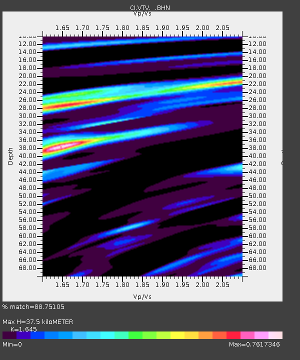
| Estimated Moho Depth: |
37.5 km |
| Estimated Crust Vp/Vs: |
1.64 |
| Assumed Crust Vp: |
6.276 km/s |
| Estimated Crust Vs: |
3.815 km/s |
| Estimated Crust Poisson's Ratio: |
0.21 |
|
| Radial Match: |
88.75105 % |
| Radial Bump: |
400 |
| Transverse Match: |
83.85642 % |
| Transverse Bump: |
400 |
| SOD ConfigId: |
4770 |
| Insert Time: |
2010-03-05 22:15:38.701 +0000 |
| GWidth: |
2.5 |
| Max Bumps: |
400 |
| Tol: |
0.001 |
|

Signal To Noise
| Channel | StoN | STA | LTA |
| CI:VTV: :BHN:19970920T16:23:32.602014Z | 1.8000257 | 1.4157089E-6 | 7.8649373E-7 |
| CI:VTV: :BHE:19970920T16:23:32.602014Z | 1.8021095 | 1.4423682E-6 | 8.003777E-7 |
| CI:VTV: :BHZ:19970920T16:23:32.602014Z | 3.501801 | 2.4313506E-6 | 6.9431434E-7 |
| Arrivals |
| Ps | 4.0 SECOND |
| PpPs | 15 SECOND |
| PsPs/PpSs | 19 SECOND |


