You are here: Home > Network List > CI - Caltech Regional Seismic Network Stations List
> Station VTV Victorville, California, USA > Earthquake Result Viewer
VTV Victorville, California, USA - Earthquake Result Viewer

| Earthquake location: |
South Of Fiji Islands |
| Earthquake latitude/longitude: |
-22.1/-176.8 |
| Earthquake time(UTC): |
1997/10/14 (287) 09:53:18 GMT |
| Earthquake Depth: |
167 km |
| Earthquake Magnitude: |
6.7 MB, 7.7 UNKNOWN, 7.4 ME |
| Earthquake Catalog/Contributor: |
WHDF/NEIC |
|
| Network: |
CI Caltech Regional Seismic Network |
| Station: |
VTV Victorville, California, USA |
| Lat/Lon: |
34.56 N/117.33 W |
| Elevation: |
812 m |
|
| Distance: |
79.8 deg |
| Az: |
46.236 deg |
| Baz: |
234.247 deg |
| Ray Param: |
0.04833948 |
| Estimated Moho Depth: |
38.5 km |
| Estimated Crust Vp/Vs: |
1.60 |
| Assumed Crust Vp: |
6.276 km/s |
| Estimated Crust Vs: |
3.922 km/s |
| Estimated Crust Poisson's Ratio: |
0.18 |
|
| Radial Match: |
97.41495 % |
| Radial Bump: |
365 |
| Transverse Match: |
93.40312 % |
| Transverse Bump: |
400 |
| SOD ConfigId: |
4770 |
| Insert Time: |
2010-03-05 22:15:41.100 +0000 |
| GWidth: |
2.5 |
| Max Bumps: |
400 |
| Tol: |
0.001 |
|
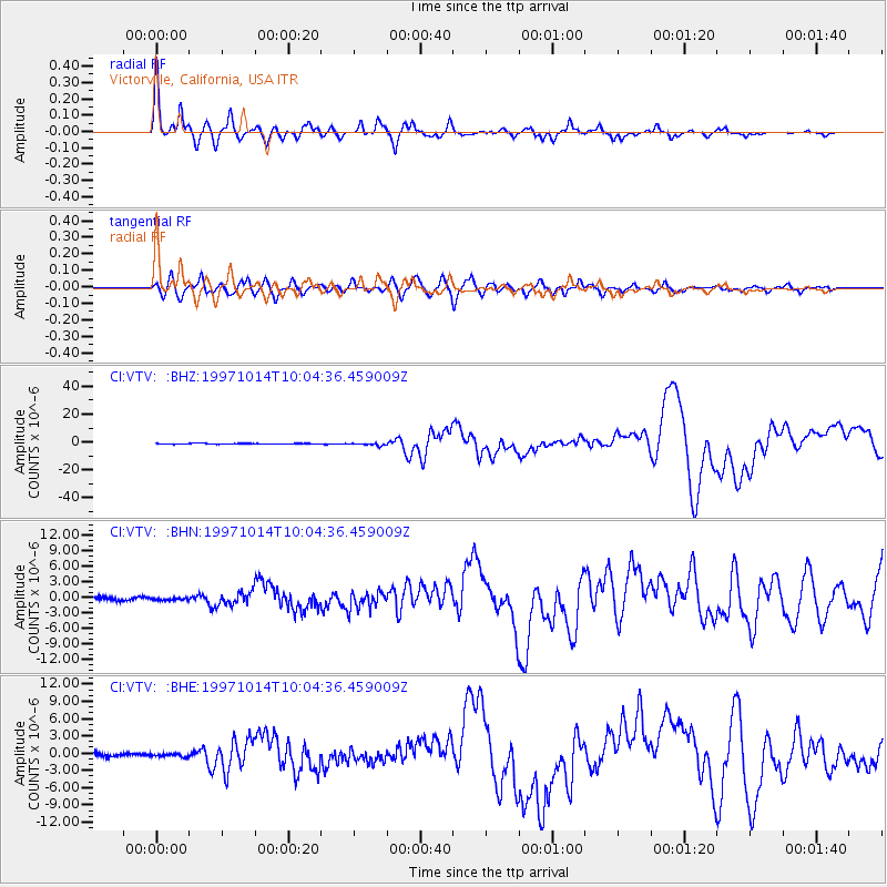
Signal To Noise
| Channel | StoN | STA | LTA |
| CI:VTV: :BHN:19971014T10:04:36.459009Z | 0.7600396 | 2.3885406E-7 | 3.1426526E-7 |
| CI:VTV: :BHE:19971014T10:04:36.459009Z | 1.1632673 | 3.7048406E-7 | 3.1848575E-7 |
| CI:VTV: :BHZ:19971014T10:04:36.459009Z | 3.3615623 | 9.3009635E-7 | 2.7668574E-7 |
| Arrivals |
| Ps | 3.8 SECOND |
| PpPs | 15 SECOND |
| PsPs/PpSs | 19 SECOND |


