You are here: Home > Network List > CI - Caltech Regional Seismic Network Stations List
> Station VTV Victorville, California, USA > Earthquake Result Viewer
VTV Victorville, California, USA - Earthquake Result Viewer
| Earthquake location: |
Near Coast Of Central Chile |
| Earthquake latitude/longitude: |
-30.9/-71.2 |
| Earthquake time(UTC): |
1997/10/15 (288) 01:03:33 GMT |
| Earthquake Depth: |
58 km |
| Earthquake Magnitude: |
6.8 MB, 6.8 MS, 7.3 UNKNOWN, 7.1 MW |
| Earthquake Catalog/Contributor: |
WHDF/NEIC |
|
| Network: |
CI Caltech Regional Seismic Network |
| Station: |
VTV Victorville, California, USA |
| Lat/Lon: |
34.56 N/117.33 W |
| Elevation: |
812 m |
|
| Distance: |
78.3 deg |
| Az: |
322.599 deg |
| Baz: |
140.772 deg |
| Ray Param: |
0.04962417 |
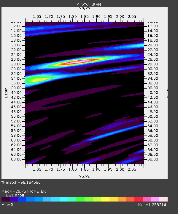
| Estimated Moho Depth: |
26.75 km |
| Estimated Crust Vp/Vs: |
1.82 |
| Assumed Crust Vp: |
6.276 km/s |
| Estimated Crust Vs: |
3.444 km/s |
| Estimated Crust Poisson's Ratio: |
0.28 |
|
| Radial Match: |
96.184586 % |
| Radial Bump: |
400 |
| Transverse Match: |
89.69684 % |
| Transverse Bump: |
400 |
| SOD ConfigId: |
6273 |
| Insert Time: |
2010-03-05 22:15:50.040 +0000 |
| GWidth: |
2.5 |
| Max Bumps: |
400 |
| Tol: |
0.001 |
|
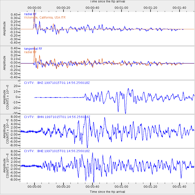
Signal To Noise
| Channel | StoN | STA | LTA |
| CI:VTV: :BHN:19971015T01:14:56.256018Z | 1.4100794 | 3.6126596E-7 | 2.5620258E-7 |
| CI:VTV: :BHE:19971015T01:14:56.256018Z | 1.0558716 | 3.2725995E-7 | 3.0994295E-7 |
| CI:VTV: :BHZ:19971015T01:14:56.256018Z | 3.5676932 | 7.230684E-7 | 2.0267113E-7 |
| Arrivals |
| Ps | 3.6 SECOND |
| PpPs | 12 SECOND |
| PsPs/PpSs | 15 SECOND |


