You are here: Home > Network List > CI - Caltech Regional Seismic Network Stations List
> Station VTV Victorville, California, USA > Earthquake Result Viewer
VTV Victorville, California, USA - Earthquake Result Viewer
| Earthquake location: |
Fiji Islands Region |
| Earthquake latitude/longitude: |
-17.7/-179.0 |
| Earthquake time(UTC): |
1998/03/29 (088) 20:38:40 GMT |
| Earthquake Depth: |
530 km |
| Earthquake Magnitude: |
5.6 MB |
| Earthquake Catalog/Contributor: |
WHDF/NEIC |
|
| Network: |
CI Caltech Regional Seismic Network |
| Station: |
VTV Victorville, California, USA |
| Lat/Lon: |
34.56 N/117.33 W |
| Elevation: |
812 m |
|
| Distance: |
78.3 deg |
| Az: |
47.909 deg |
| Baz: |
239.019 deg |
| Ray Param: |
0.04812908 |
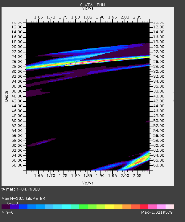
| Estimated Moho Depth: |
26.5 km |
| Estimated Crust Vp/Vs: |
1.80 |
| Assumed Crust Vp: |
6.276 km/s |
| Estimated Crust Vs: |
3.487 km/s |
| Estimated Crust Poisson's Ratio: |
0.28 |
|
| Radial Match: |
84.79368 % |
| Radial Bump: |
400 |
| Transverse Match: |
44.679386 % |
| Transverse Bump: |
400 |
| SOD ConfigId: |
3770 |
| Insert Time: |
2010-03-05 22:15:51.723 +0000 |
| GWidth: |
2.5 |
| Max Bumps: |
400 |
| Tol: |
0.001 |
|

Signal To Noise
| Channel | StoN | STA | LTA |
| CI:VTV: :BHN:19980329T20:49:14.902014Z | 0.45114478 | 5.1243876E-7 | 1.1358633E-6 |
| CI:VTV: :BHE:19980329T20:49:14.902014Z | 1.4796231 | 2.1936773E-6 | 1.4825921E-6 |
| CI:VTV: :BHZ:19980329T20:49:14.902014Z | 0.68458635 | 9.1673024E-7 | 1.339101E-6 |
| Arrivals |
| Ps | 3.5 SECOND |
| PpPs | 12 SECOND |
| PsPs/PpSs | 15 SECOND |


