You are here: Home > Network List > CI - Caltech Regional Seismic Network Stations List
> Station VTV Victorville, California, USA > Earthquake Result Viewer
VTV Victorville, California, USA - Earthquake Result Viewer
| Earthquake location: |
Near Coast Of Northern Chile |
| Earthquake latitude/longitude: |
-23.9/-70.2 |
| Earthquake time(UTC): |
1998/01/30 (030) 12:16:08 GMT |
| Earthquake Depth: |
42 km |
| Earthquake Magnitude: |
6.3 MB, 6.5 MS, 7.0 UNKNOWN, 6.7 ME |
| Earthquake Catalog/Contributor: |
WHDF/NEIC |
|
| Network: |
CI Caltech Regional Seismic Network |
| Station: |
VTV Victorville, California, USA |
| Lat/Lon: |
34.56 N/117.33 W |
| Elevation: |
812 m |
|
| Distance: |
73.4 deg |
| Az: |
320.86 deg |
| Baz: |
135.577 deg |
| Ray Param: |
0.052981194 |
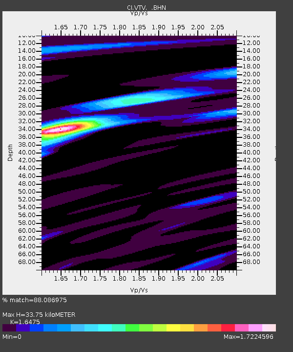
| Estimated Moho Depth: |
33.75 km |
| Estimated Crust Vp/Vs: |
1.65 |
| Assumed Crust Vp: |
6.276 km/s |
| Estimated Crust Vs: |
3.809 km/s |
| Estimated Crust Poisson's Ratio: |
0.21 |
|
| Radial Match: |
88.086975 % |
| Radial Bump: |
400 |
| Transverse Match: |
68.20557 % |
| Transverse Bump: |
400 |
| SOD ConfigId: |
3770 |
| Insert Time: |
2010-03-05 22:15:53.218 +0000 |
| GWidth: |
2.5 |
| Max Bumps: |
400 |
| Tol: |
0.001 |
|

Signal To Noise
| Channel | StoN | STA | LTA |
| CI:VTV: :BHN:19980130T12:27:05.152002Z | 0.9255667 | 3.504744E-7 | 3.7865928E-7 |
| CI:VTV: :BHE:19980130T12:27:05.152002Z | 0.71993554 | 4.6348524E-7 | 6.4378713E-7 |
| CI:VTV: :BHZ:19980130T12:27:05.152002Z | 2.5159783 | 1.2775777E-6 | 5.0778567E-7 |
| Arrivals |
| Ps | 3.6 SECOND |
| PpPs | 14 SECOND |
| PsPs/PpSs | 17 SECOND |


