You are here: Home > Network List > CI - Caltech Regional Seismic Network Stations List
> Station VTV Victorville, California, USA > Earthquake Result Viewer
VTV Victorville, California, USA - Earthquake Result Viewer
| Earthquake location: |
Near Coast Of Guatemala |
| Earthquake latitude/longitude: |
13.7/-90.7 |
| Earthquake time(UTC): |
1998/05/10 (130) 06:05:58 GMT |
| Earthquake Depth: |
33 km |
| Earthquake Magnitude: |
5.3 MB, 5.9 MS, 6.3 UNKNOWN, 5.3 MD |
| Earthquake Catalog/Contributor: |
WHDF/NEIC |
|
| Network: |
CI Caltech Regional Seismic Network |
| Station: |
VTV Victorville, California, USA |
| Lat/Lon: |
34.56 N/117.33 W |
| Elevation: |
812 m |
|
| Distance: |
31.8 deg |
| Az: |
315.475 deg |
| Baz: |
124.323 deg |
| Ray Param: |
0.07888137 |
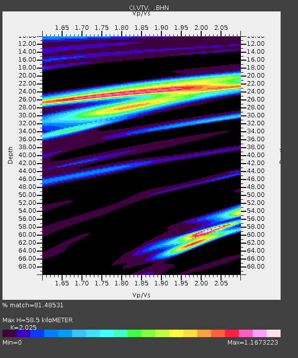
| Estimated Moho Depth: |
58.5 km |
| Estimated Crust Vp/Vs: |
2.03 |
| Assumed Crust Vp: |
6.276 km/s |
| Estimated Crust Vs: |
3.099 km/s |
| Estimated Crust Poisson's Ratio: |
0.34 |
|
| Radial Match: |
81.48531 % |
| Radial Bump: |
400 |
| Transverse Match: |
67.60589 % |
| Transverse Bump: |
358 |
| SOD ConfigId: |
4770 |
| Insert Time: |
2010-03-05 22:16:07.423 +0000 |
| GWidth: |
2.5 |
| Max Bumps: |
400 |
| Tol: |
0.001 |
|
Signal To Noise
| Channel | StoN | STA | LTA |
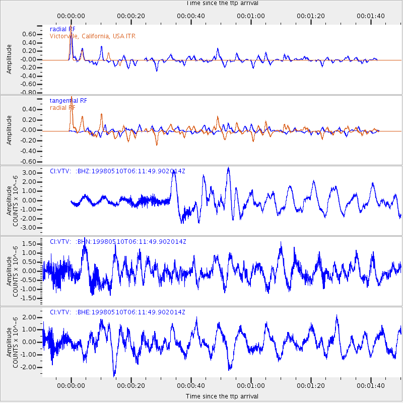
| CI:VTV: :BHN:19980510T06:11:49.902014Z | 2.1519039 | 6.137698E-7 | 2.8522177E-7 |
| CI:VTV: :BHE:19980510T06:11:49.902014Z | 1.4484831 | 5.710409E-7 | 3.9423375E-7 |
| CI:VTV: :BHZ:19980510T06:11:49.902014Z | 4.3988156 | 1.4535723E-6 | 3.3044628E-7 |
| Arrivals |
| Ps | 10 SECOND |
| PpPs | 26 SECOND |
| PsPs/PpSs | 37 SECOND |


