You are here: Home > Network List > CI - Caltech Regional Seismic Network Stations List
> Station TIN Tinemaha, Big Pine, CA, USA > Earthquake Result Viewer
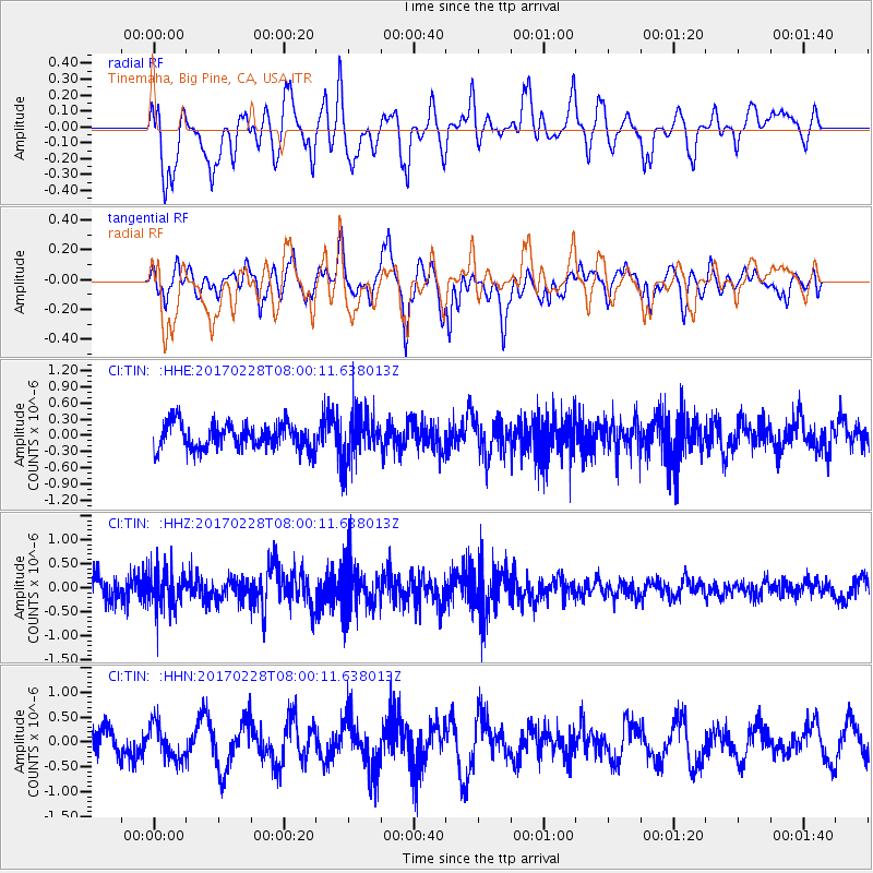
TIN Tinemaha, Big Pine, CA, USA - Earthquake Result Viewer
*The percent match for this event was below the threshold and hence no stack was calculated.
| Earthquake location: |
Near East Coast Of Honshu, Japan |
| Earthquake latitude/longitude: |
37.6/141.3 |
| Earthquake time(UTC): |
2017/02/28 (059) 07:49:01 GMT |
| Earthquake Depth: |
38 km |
| Earthquake Magnitude: |
5.7 Mww |
| Earthquake Catalog/Contributor: |
NEIC PDE/us |
|
| Network: |
CI Caltech Regional Seismic Network |
| Station: |
TIN Tinemaha, Big Pine, CA, USA |
| Lat/Lon: |
37.05 N/118.23 W |
| Elevation: |
1197 m |
|
| Distance: |
75.6 deg |
| Az: |
54.313 deg |
| Baz: |
306.221 deg |
| Ray Param: |
$rayparam |
*The percent match for this event was below the threshold and hence was not used in the summary stack. |
|
| Radial Match: |
57.132088 % |
| Radial Bump: |
400 |
| Transverse Match: |
65.37773 % |
| Transverse Bump: |
400 |
| SOD ConfigId: |
11737051 |
| Insert Time: |
2019-04-26 20:24:40.189 +0000 |
| GWidth: |
2.5 |
| Max Bumps: |
400 |
| Tol: |
0.001 |
|
Signal To Noise
| Channel | StoN | STA | LTA |
| CI:TIN: :HHZ:20170228T08:00:11.638013Z | 2.1961284 | 3.981469E-7 | 1.8129491E-7 |
| CI:TIN: :HHN:20170228T08:00:11.638013Z | 1.2358733 | 3.5309017E-7 | 2.8570093E-7 |
| CI:TIN: :HHE:20170228T08:00:11.638013Z | 1.7990053 | 4.3126641E-7 | 2.3972493E-7 |
| Arrivals |
| Ps | |
| PpPs | |
| PsPs/PpSs | |


