You are here: Home > Network List > CI - Caltech Regional Seismic Network Stations List
> Station VTV Victorville, California, USA > Earthquake Result Viewer
VTV Victorville, California, USA - Earthquake Result Viewer
| Earthquake location: |
Near Coast Of Central Chile |
| Earthquake latitude/longitude: |
-29.5/-71.7 |
| Earthquake time(UTC): |
1998/09/03 (246) 17:37:58 GMT |
| Earthquake Depth: |
27 km |
| Earthquake Magnitude: |
6.2 MB, 6.6 MS, 6.5 UNKNOWN, 6.4 ME |
| Earthquake Catalog/Contributor: |
WHDF/NEIC |
|
| Network: |
CI Caltech Regional Seismic Network |
| Station: |
VTV Victorville, California, USA |
| Lat/Lon: |
34.56 N/117.33 W |
| Elevation: |
812 m |
|
| Distance: |
76.9 deg |
| Az: |
322.724 deg |
| Baz: |
140.203 deg |
| Ray Param: |
0.050675 |
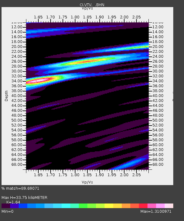
| Estimated Moho Depth: |
33.75 km |
| Estimated Crust Vp/Vs: |
1.64 |
| Assumed Crust Vp: |
6.276 km/s |
| Estimated Crust Vs: |
3.827 km/s |
| Estimated Crust Poisson's Ratio: |
0.20 |
|
| Radial Match: |
89.69071 % |
| Radial Bump: |
400 |
| Transverse Match: |
84.315926 % |
| Transverse Bump: |
400 |
| SOD ConfigId: |
3770 |
| Insert Time: |
2010-03-05 22:16:12.986 +0000 |
| GWidth: |
2.5 |
| Max Bumps: |
400 |
| Tol: |
0.001 |
|
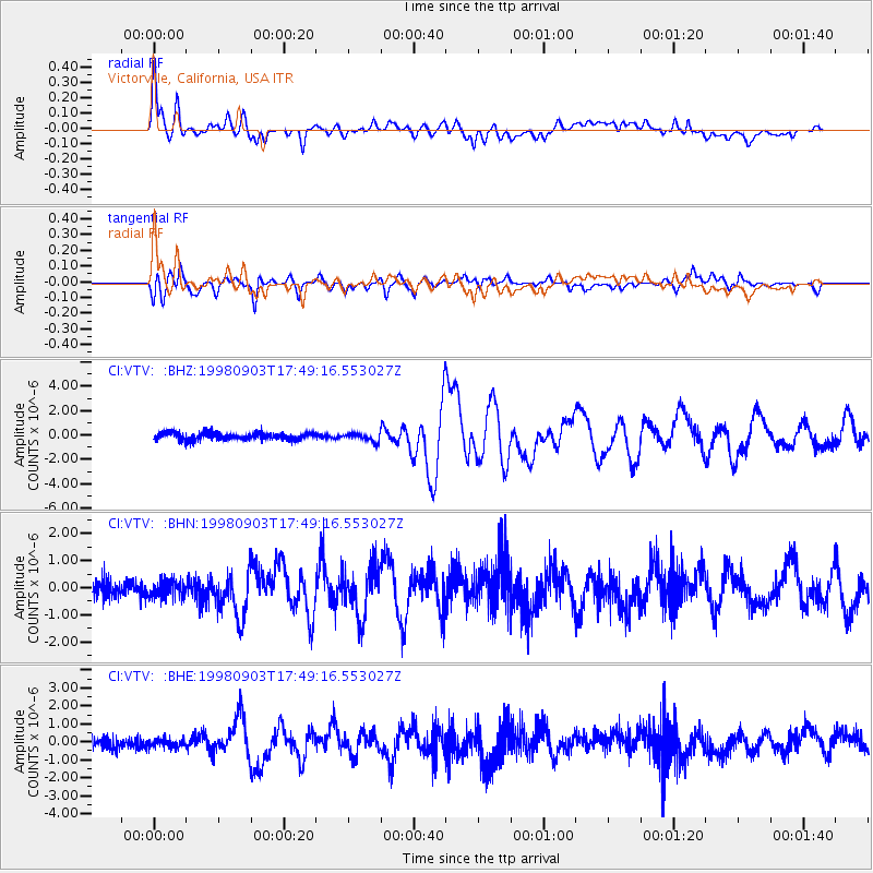
Signal To Noise
| Channel | StoN | STA | LTA |
| CI:VTV: :BHN:19980903T17:49:16.553027Z | 0.7527477 | 3.2273175E-7 | 4.2873828E-7 |
| CI:VTV: :BHE:19980903T17:49:16.553027Z | 0.462106 | 2.391623E-7 | 5.175486E-7 |
| CI:VTV: :BHZ:19980903T17:49:16.553027Z | 1.1239102 | 3.2737083E-7 | 2.9127844E-7 |
| Arrivals |
| Ps | 3.6 SECOND |
| PpPs | 14 SECOND |
| PsPs/PpSs | 17 SECOND |


