You are here: Home > Network List > CI - Caltech Regional Seismic Network Stations List
> Station VTV Victorville, California, USA > Earthquake Result Viewer
VTV Victorville, California, USA - Earthquake Result Viewer
| Earthquake location: |
Off East Coast Of Kamchatka |
| Earthquake latitude/longitude: |
52.9/160.1 |
| Earthquake time(UTC): |
1998/06/01 (152) 05:34:03 GMT |
| Earthquake Depth: |
44 km |
| Earthquake Magnitude: |
6.2 MB, 6.3 MS, 6.5 UNKNOWN, 6.4 MW |
| Earthquake Catalog/Contributor: |
WHDF/NEIC |
|
| Network: |
CI Caltech Regional Seismic Network |
| Station: |
VTV Victorville, California, USA |
| Lat/Lon: |
34.56 N/117.33 W |
| Elevation: |
812 m |
|
| Distance: |
59.1 deg |
| Az: |
72.526 deg |
| Baz: |
315.547 deg |
| Ray Param: |
0.062320087 |
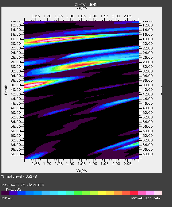
| Estimated Moho Depth: |
37.75 km |
| Estimated Crust Vp/Vs: |
1.63 |
| Assumed Crust Vp: |
6.276 km/s |
| Estimated Crust Vs: |
3.838 km/s |
| Estimated Crust Poisson's Ratio: |
0.20 |
|
| Radial Match: |
87.65278 % |
| Radial Bump: |
400 |
| Transverse Match: |
78.655815 % |
| Transverse Bump: |
400 |
| SOD ConfigId: |
3770 |
| Insert Time: |
2010-03-05 22:16:14.522 +0000 |
| GWidth: |
2.5 |
| Max Bumps: |
400 |
| Tol: |
0.001 |
|

Signal To Noise
| Channel | StoN | STA | LTA |
| CI:VTV: :BHN:19980601T05:43:28.703003Z | 1.1161356 | 7.1035595E-7 | 6.3644234E-7 |
| CI:VTV: :BHE:19980601T05:43:28.703003Z | 1.1848103 | 7.297157E-7 | 6.158925E-7 |
| CI:VTV: :BHZ:19980601T05:43:28.703003Z | 1.3730034 | 8.812378E-7 | 6.418322E-7 |
| Arrivals |
| Ps | 4.0 SECOND |
| PpPs | 15 SECOND |
| PsPs/PpSs | 19 SECOND |


