You are here: Home > Network List > CI - Caltech Regional Seismic Network Stations List
> Station VTV Victorville, California, USA > Earthquake Result Viewer
VTV Victorville, California, USA - Earthquake Result Viewer
| Earthquake location: |
Honduras |
| Earthquake latitude/longitude: |
15.8/-88.3 |
| Earthquake time(UTC): |
1999/07/11 (192) 14:14:16 GMT |
| Earthquake Depth: |
10 km |
| Earthquake Magnitude: |
6.0 MB, 6.6 MS, 6.7 MW, 6.3 ME |
| Earthquake Catalog/Contributor: |
WHDF/NEIC |
|
| Network: |
CI Caltech Regional Seismic Network |
| Station: |
VTV Victorville, California, USA |
| Lat/Lon: |
34.56 N/117.33 W |
| Elevation: |
812 m |
|
| Distance: |
32.0 deg |
| Az: |
311.062 deg |
| Baz: |
118.406 deg |
| Ray Param: |
0.078817 |
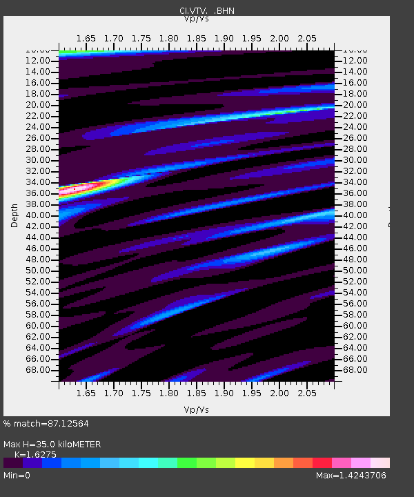
| Estimated Moho Depth: |
35.0 km |
| Estimated Crust Vp/Vs: |
1.63 |
| Assumed Crust Vp: |
6.276 km/s |
| Estimated Crust Vs: |
3.856 km/s |
| Estimated Crust Poisson's Ratio: |
0.20 |
|
| Radial Match: |
87.12564 % |
| Radial Bump: |
400 |
| Transverse Match: |
64.421555 % |
| Transverse Bump: |
400 |
| SOD ConfigId: |
3787 |
| Insert Time: |
2010-03-05 22:16:34.573 +0000 |
| GWidth: |
2.5 |
| Max Bumps: |
400 |
| Tol: |
0.001 |
|

Signal To Noise
| Channel | StoN | STA | LTA |
| CI:VTV: :BHN:19990711T14:20:12.614015Z | 1.5420219 | 3.8904597E-7 | 2.52296E-7 |
| CI:VTV: :BHE:19990711T14:20:12.614015Z | 2.3380604 | 5.548661E-7 | 2.37319E-7 |
| CI:VTV: :BHZ:19990711T14:20:12.614015Z | 4.9318542 | 7.666578E-7 | 1.5545022E-7 |
| Arrivals |
| Ps | 3.8 SECOND |
| PpPs | 13 SECOND |
| PsPs/PpSs | 17 SECOND |


