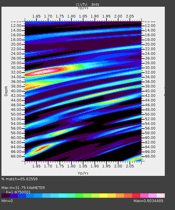
VTV Victorville, California, USA - Earthquake Result Viewer

Earthquake location: Kodiak Island Region, Alaska
Earthquake latitude/longitude: 56.4/-152.9
Earthquake time(UTC): 1999/05/07 (127) 14:13:52 GMT
Earthquake Depth: 20 km
Earthquake Magnitude: 5.7 MB, 6.1 MS, 6.4 MW, 5.7 ME
Earthquake Catalog/Contributor: WHDF/NEIC
Network: CI Caltech Regional Seismic Network
Station: VTV Victorville, California, USA
Lat/Lon: 34.56 N/117.33 W
Elevation: 812 m
Distance: 32.6 deg
Az: 116.92 deg
Baz: 323.101 deg
Ray Param: 0.078558445
Estimated Moho Depth: 31.75 km
Estimated Crust Vp/Vs: 1.68
Assumed Crust Vp: 6.276 km/s
Estimated Crust Vs: 3.747 km/s
Estimated Crust Poisson's Ratio: 0.22
Radial Match: 85.82559 %
Radial Bump: 400
Transverse Match: 57.539783 %
Transverse Bump: 400
SOD ConfigId: 3787
Insert Time: 2010-03-05 22:16:35.754 +0000
GWidth: 2.5
Max Bumps: 400
Tol: 0.001

Signal To Noise

ChannelStoNSTALTA
CI:VTV: :BHN:19990507T14:19:51.96199Z1.4531845.765072E-73.9672005E-7
CI:VTV: :BHE:19990507T14:19:51.96199Z1.2373674.9099805E-73.9680876E-7
CI:VTV: :BHZ:19990507T14:19:51.96199Z2.51562296.143856E-72.4422803E-7
Arrivals
Ps3.7 SECOND
PpPs13 SECOND
PsPs/PpSs16 SECOND