You are here: Home > Network List > CI - Caltech Regional Seismic Network Stations List
> Station VTV Victorville, California, USA > Earthquake Result Viewer
VTV Victorville, California, USA - Earthquake Result Viewer
| Earthquake location: |
Southern Bolivia |
| Earthquake latitude/longitude: |
-20.9/-67.3 |
| Earthquake time(UTC): |
1999/09/15 (258) 03:01:24 GMT |
| Earthquake Depth: |
218 km |
| Earthquake Magnitude: |
6.0 MB, 6.4 MW, 6.4 MW |
| Earthquake Catalog/Contributor: |
WHDF/NEIC |
|
| Network: |
CI Caltech Regional Seismic Network |
| Station: |
VTV Victorville, California, USA |
| Lat/Lon: |
34.56 N/117.33 W |
| Elevation: |
812 m |
|
| Distance: |
72.9 deg |
| Az: |
318.537 deg |
| Baz: |
131.411 deg |
| Ray Param: |
0.05279388 |
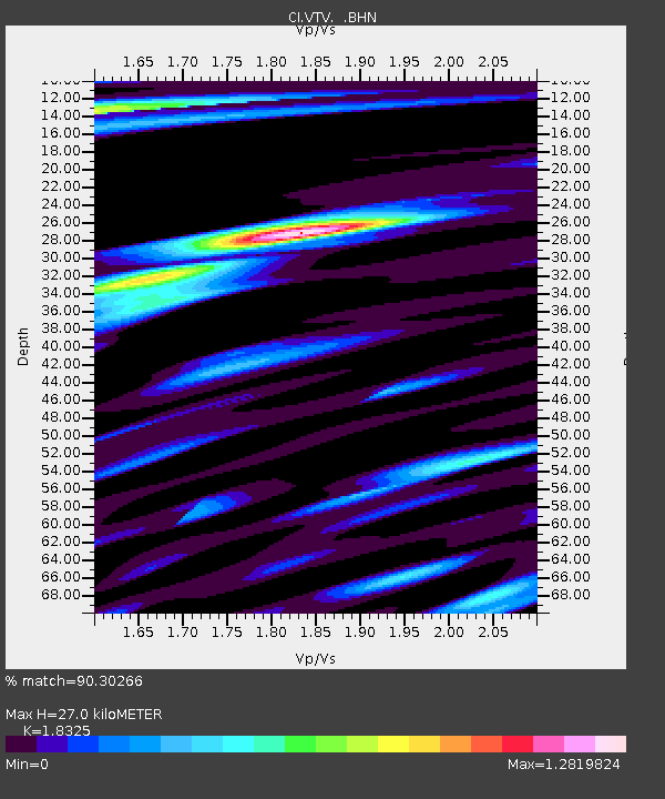
| Estimated Moho Depth: |
27.0 km |
| Estimated Crust Vp/Vs: |
1.83 |
| Assumed Crust Vp: |
6.276 km/s |
| Estimated Crust Vs: |
3.425 km/s |
| Estimated Crust Poisson's Ratio: |
0.29 |
|
| Radial Match: |
90.30266 % |
| Radial Bump: |
400 |
| Transverse Match: |
88.134834 % |
| Transverse Bump: |
400 |
| SOD ConfigId: |
3787 |
| Insert Time: |
2010-03-05 22:16:36.889 +0000 |
| GWidth: |
2.5 |
| Max Bumps: |
400 |
| Tol: |
0.001 |
|

Signal To Noise
| Channel | StoN | STA | LTA |
| CI:VTV: :BHN:19990915T03:11:58.245029Z | 1.0868001 | 4.590944E-7 | 4.224276E-7 |
| CI:VTV: :BHE:19990915T03:11:58.245029Z | 1.1339219 | 4.6415667E-7 | 4.0933742E-7 |
| CI:VTV: :BHZ:19990915T03:11:58.245029Z | 5.4511676 | 1.3090984E-6 | 2.401501E-7 |
| Arrivals |
| Ps | 3.7 SECOND |
| PpPs | 12 SECOND |
| PsPs/PpSs | 16 SECOND |


