You are here: Home > Network List > IU - Global Seismograph Network (GSN - IRIS/USGS) Stations List
> Station CTAO Charters Towers, Australia > Earthquake Result Viewer
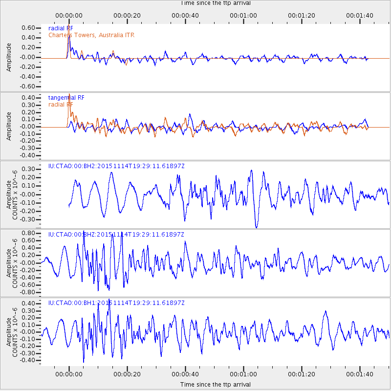
CTAO Charters Towers, Australia - Earthquake Result Viewer
*The percent match for this event was below the threshold and hence no stack was calculated.
| Earthquake location: |
Northwest Of Ryukyu Islands |
| Earthquake latitude/longitude: |
31.4/129.0 |
| Earthquake time(UTC): |
2015/11/14 (318) 19:20:21 GMT |
| Earthquake Depth: |
26 km |
| Earthquake Magnitude: |
5.7 MB |
| Earthquake Catalog/Contributor: |
NEIC PDE/NEIC ALERT |
|
| Network: |
IU Global Seismograph Network (GSN - IRIS/USGS) |
| Station: |
CTAO Charters Towers, Australia |
| Lat/Lon: |
20.09 S/146.25 E |
| Elevation: |
357 m |
|
| Distance: |
53.8 deg |
| Az: |
159.752 deg |
| Baz: |
341.653 deg |
| Ray Param: |
$rayparam |
*The percent match for this event was below the threshold and hence was not used in the summary stack. |
|
| Radial Match: |
66.74768 % |
| Radial Bump: |
400 |
| Transverse Match: |
57.268543 % |
| Transverse Bump: |
400 |
| SOD ConfigId: |
1259291 |
| Insert Time: |
2015-11-28 21:18:48.922 +0000 |
| GWidth: |
2.5 |
| Max Bumps: |
400 |
| Tol: |
0.001 |
|
Signal To Noise
| Channel | StoN | STA | LTA |
| IU:CTAO:00:BHZ:20151114T19:29:11.61897Z | 2.6412065 | 2.9334808E-7 | 1.1106594E-7 |
| IU:CTAO:00:BH1:20151114T19:29:11.61897Z | 1.0462108 | 1.3157641E-7 | 1.2576474E-7 |
| IU:CTAO:00:BH2:20151114T19:29:11.61897Z | 0.66226536 | 8.848867E-8 | 1.3361513E-7 |
| Arrivals |
| Ps | |
| PpPs | |
| PsPs/PpSs | |


