You are here: Home > Network List > TA - USArray Transportable Network (new EarthScope stations) Stations List
> Station A21K Barrow, AK, USA > Earthquake Result Viewer
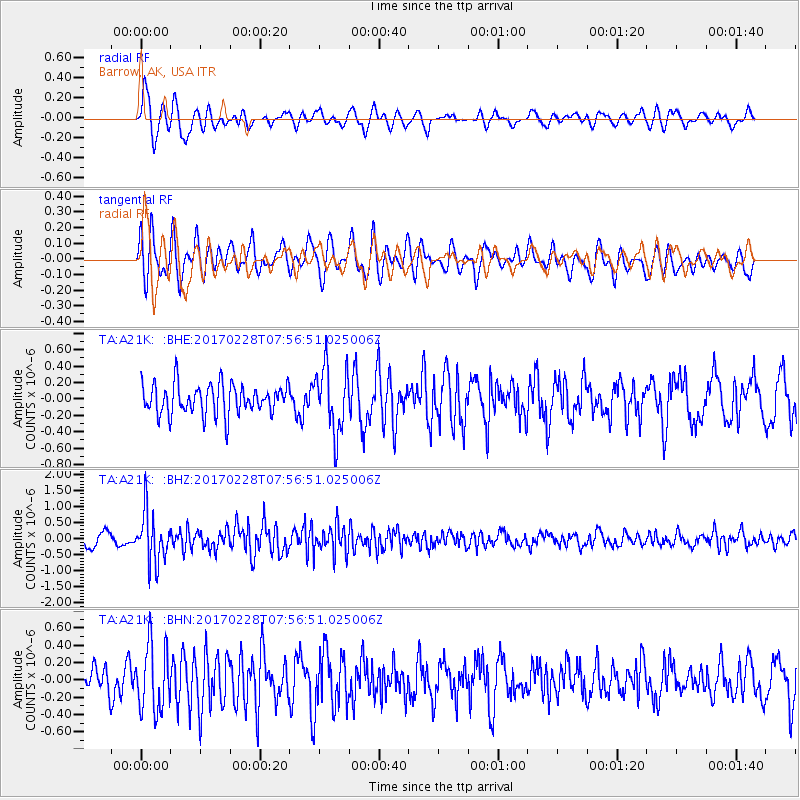
A21K Barrow, AK, USA - Earthquake Result Viewer
*The percent match for this event was below the threshold and hence no stack was calculated.
| Earthquake location: |
Near East Coast Of Honshu, Japan |
| Earthquake latitude/longitude: |
37.6/141.3 |
| Earthquake time(UTC): |
2017/02/28 (059) 07:49:01 GMT |
| Earthquake Depth: |
38 km |
| Earthquake Magnitude: |
5.7 Mww |
| Earthquake Catalog/Contributor: |
NEIC PDE/us |
|
| Network: |
TA USArray Transportable Network (new EarthScope stations) |
| Station: |
A21K Barrow, AK, USA |
| Lat/Lon: |
71.32 N/156.62 W |
| Elevation: |
577 m |
|
| Distance: |
46.0 deg |
| Az: |
23.312 deg |
| Baz: |
257.427 deg |
| Ray Param: |
$rayparam |
*The percent match for this event was below the threshold and hence was not used in the summary stack. |
|
| Radial Match: |
68.95266 % |
| Radial Bump: |
400 |
| Transverse Match: |
57.52168 % |
| Transverse Bump: |
400 |
| SOD ConfigId: |
11737051 |
| Insert Time: |
2019-04-26 20:29:56.520 +0000 |
| GWidth: |
2.5 |
| Max Bumps: |
400 |
| Tol: |
0.001 |
|
Signal To Noise
| Channel | StoN | STA | LTA |
| TA:A21K: :BHZ:20170228T07:56:51.025006Z | 5.0475945 | 7.805961E-7 | 1.5464715E-7 |
| TA:A21K: :BHN:20170228T07:56:51.025006Z | 2.2028472 | 3.8087023E-7 | 1.7289908E-7 |
| TA:A21K: :BHE:20170228T07:56:51.025006Z | 2.2112403 | 4.0447404E-7 | 1.8291728E-7 |
| Arrivals |
| Ps | |
| PpPs | |
| PsPs/PpSs | |


