You are here: Home > Network List > CI - Caltech Regional Seismic Network Stations List
> Station VTV Victorville, California, USA > Earthquake Result Viewer
VTV Victorville, California, USA - Earthquake Result Viewer
| Earthquake location: |
Santa Cruz Islands |
| Earthquake latitude/longitude: |
-12.9/166.7 |
| Earthquake time(UTC): |
1999/02/06 (037) 21:47:59 GMT |
| Earthquake Depth: |
90 km |
| Earthquake Magnitude: |
6.3 MB, 7.3 MS, 7.4 MW, 7.0 ME |
| Earthquake Catalog/Contributor: |
WHDF/NEIC |
|
| Network: |
CI Caltech Regional Seismic Network |
| Station: |
VTV Victorville, California, USA |
| Lat/Lon: |
34.56 N/117.33 W |
| Elevation: |
812 m |
|
| Distance: |
86.0 deg |
| Az: |
53.386 deg |
| Baz: |
251.538 deg |
| Ray Param: |
0.04420097 |
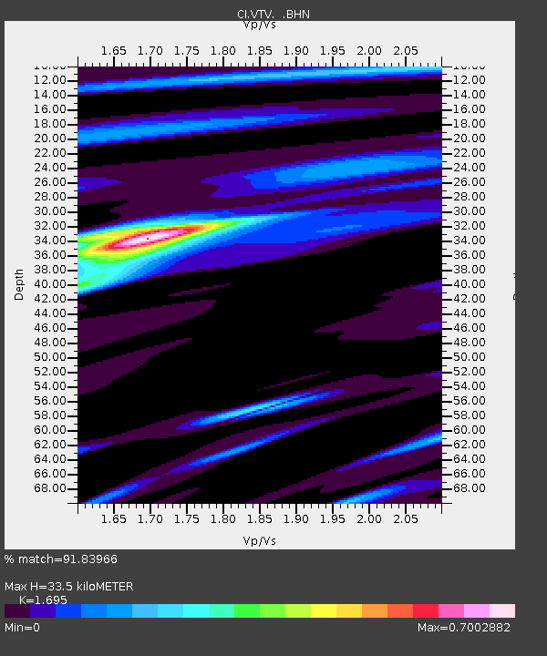
| Estimated Moho Depth: |
33.5 km |
| Estimated Crust Vp/Vs: |
1.70 |
| Assumed Crust Vp: |
6.276 km/s |
| Estimated Crust Vs: |
3.703 km/s |
| Estimated Crust Poisson's Ratio: |
0.23 |
|
| Radial Match: |
91.83966 % |
| Radial Bump: |
400 |
| Transverse Match: |
87.29737 % |
| Transverse Bump: |
400 |
| SOD ConfigId: |
3787 |
| Insert Time: |
2010-03-05 22:16:50.133 +0000 |
| GWidth: |
2.5 |
| Max Bumps: |
400 |
| Tol: |
0.001 |
|

Signal To Noise
| Channel | StoN | STA | LTA |
| CI:VTV: :BHN:19990206T21:59:58.563018Z | 1.3229997 | 6.53176E-7 | 4.9370834E-7 |
| CI:VTV: :BHE:19990206T21:59:58.563018Z | 1.166815 | 7.324416E-7 | 6.277272E-7 |
| CI:VTV: :BHZ:19990206T21:59:58.563018Z | 3.8193352 | 1.5716943E-6 | 4.115099E-7 |
| Arrivals |
| Ps | 3.8 SECOND |
| PpPs | 14 SECOND |
| PsPs/PpSs | 18 SECOND |


