You are here: Home > Network List > TA - USArray Transportable Network (new EarthScope stations) Stations List
> Station G21K Allakaket, AK, USA > Earthquake Result Viewer
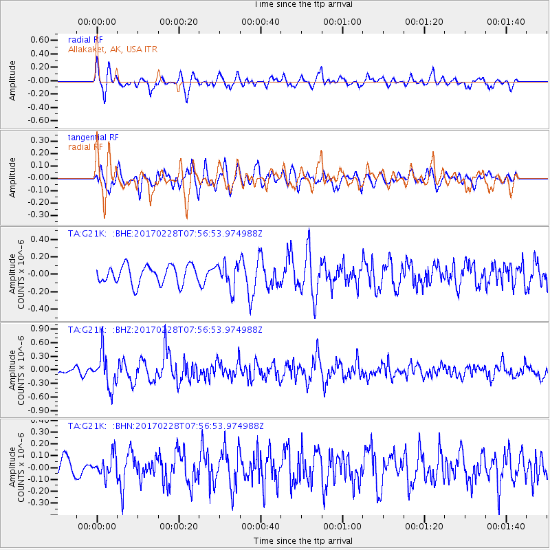
G21K Allakaket, AK, USA - Earthquake Result Viewer
*The percent match for this event was below the threshold and hence no stack was calculated.
| Earthquake location: |
Near East Coast Of Honshu, Japan |
| Earthquake latitude/longitude: |
37.6/141.3 |
| Earthquake time(UTC): |
2017/02/28 (059) 07:49:01 GMT |
| Earthquake Depth: |
38 km |
| Earthquake Magnitude: |
5.7 Mww |
| Earthquake Catalog/Contributor: |
NEIC PDE/us |
|
| Network: |
TA USArray Transportable Network (new EarthScope stations) |
| Station: |
G21K Allakaket, AK, USA |
| Lat/Lon: |
66.52 N/153.51 W |
| Elevation: |
446 m |
|
| Distance: |
46.4 deg |
| Az: |
30.164 deg |
| Baz: |
265.077 deg |
| Ray Param: |
$rayparam |
*The percent match for this event was below the threshold and hence was not used in the summary stack. |
|
| Radial Match: |
73.79351 % |
| Radial Bump: |
400 |
| Transverse Match: |
48.942776 % |
| Transverse Bump: |
400 |
| SOD ConfigId: |
11737051 |
| Insert Time: |
2019-04-26 20:30:09.401 +0000 |
| GWidth: |
2.5 |
| Max Bumps: |
400 |
| Tol: |
0.001 |
|
Signal To Noise
| Channel | StoN | STA | LTA |
| TA:G21K: :BHZ:20170228T07:56:53.974988Z | 5.544808 | 3.9129978E-7 | 7.0570486E-8 |
| TA:G21K: :BHN:20170228T07:56:53.974988Z | 0.67761034 | 8.8767656E-8 | 1.3100103E-7 |
| TA:G21K: :BHE:20170228T07:56:53.974988Z | 1.3820659 | 1.4500012E-7 | 1.04915486E-7 |
| Arrivals |
| Ps | |
| PpPs | |
| PsPs/PpSs | |


