You are here: Home > Network List > TA - USArray Transportable Network (new EarthScope stations) Stations List
> Station K22A Casper, WY, USA > Earthquake Result Viewer
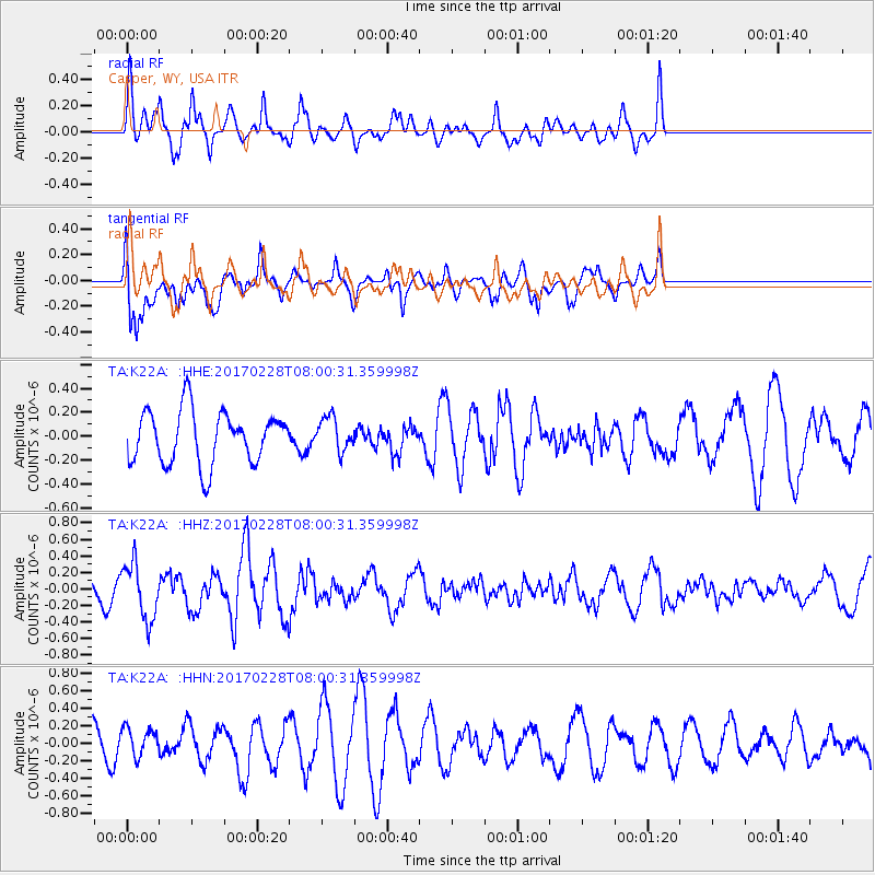
K22A Casper, WY, USA - Earthquake Result Viewer
*The percent match for this event was below the threshold and hence no stack was calculated.
| Earthquake location: |
Near East Coast Of Honshu, Japan |
| Earthquake latitude/longitude: |
37.6/141.3 |
| Earthquake time(UTC): |
2017/02/28 (059) 07:49:01 GMT |
| Earthquake Depth: |
38 km |
| Earthquake Magnitude: |
5.7 Mww |
| Earthquake Catalog/Contributor: |
NEIC PDE/us |
|
| Network: |
TA USArray Transportable Network (new EarthScope stations) |
| Station: |
K22A Casper, WY, USA |
| Lat/Lon: |
42.65 N/106.52 W |
| Elevation: |
1686 m |
|
| Distance: |
79.1 deg |
| Az: |
44.08 deg |
| Baz: |
311.472 deg |
| Ray Param: |
$rayparam |
*The percent match for this event was below the threshold and hence was not used in the summary stack. |
|
| Radial Match: |
59.077187 % |
| Radial Bump: |
398 |
| Transverse Match: |
68.79 % |
| Transverse Bump: |
400 |
| SOD ConfigId: |
11737051 |
| Insert Time: |
2019-04-26 20:30:28.211 +0000 |
| GWidth: |
2.5 |
| Max Bumps: |
400 |
| Tol: |
0.001 |
|
Signal To Noise
| Channel | StoN | STA | LTA |
| TA:K22A: :HHZ:20170228T08:00:31.359998Z | 3.4400275 | 3.367341E-7 | 9.788704E-8 |
| TA:K22A: :HHN:20170228T08:00:31.359998Z | 0.8722694 | 1.6212111E-7 | 1.8586128E-7 |
| TA:K22A: :HHE:20170228T08:00:31.359998Z | 0.6439962 | 1.4109989E-7 | 2.191005E-7 |
| Arrivals |
| Ps | |
| PpPs | |
| PsPs/PpSs | |


