You are here: Home > Network List > TA - USArray Transportable Network (new EarthScope stations) Stations List
> Station J26L Joseph Creek, AK, USA > Earthquake Result Viewer
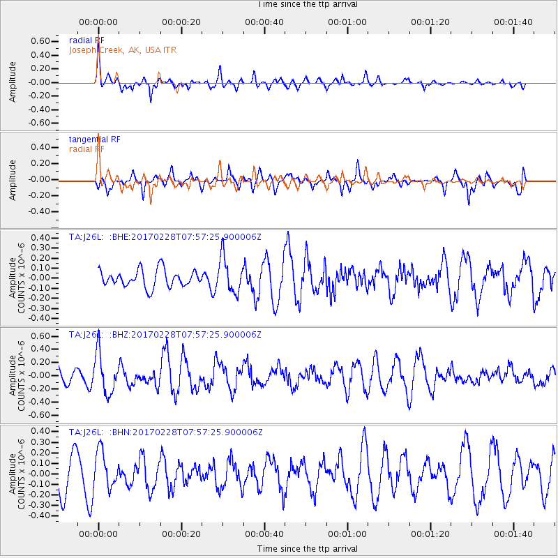
J26L Joseph Creek, AK, USA - Earthquake Result Viewer
*The percent match for this event was below the threshold and hence no stack was calculated.
| Earthquake location: |
Near East Coast Of Honshu, Japan |
| Earthquake latitude/longitude: |
37.6/141.3 |
| Earthquake time(UTC): |
2017/02/28 (059) 07:49:01 GMT |
| Earthquake Depth: |
38 km |
| Earthquake Magnitude: |
5.7 Mww |
| Earthquake Catalog/Contributor: |
NEIC PDE/us |
|
| Network: |
TA USArray Transportable Network (new EarthScope stations) |
| Station: |
J26L Joseph Creek, AK, USA |
| Lat/Lon: |
64.50 N/143.56 W |
| Elevation: |
1144 m |
|
| Distance: |
50.5 deg |
| Az: |
32.811 deg |
| Baz: |
275.876 deg |
| Ray Param: |
$rayparam |
*The percent match for this event was below the threshold and hence was not used in the summary stack. |
|
| Radial Match: |
70.440216 % |
| Radial Bump: |
369 |
| Transverse Match: |
54.70938 % |
| Transverse Bump: |
373 |
| SOD ConfigId: |
11737051 |
| Insert Time: |
2019-04-26 20:30:28.228 +0000 |
| GWidth: |
2.5 |
| Max Bumps: |
400 |
| Tol: |
0.001 |
|
Signal To Noise
| Channel | StoN | STA | LTA |
| TA:J26L: :BHZ:20170228T07:57:25.900006Z | 3.4856975 | 3.1767186E-7 | 9.11358E-8 |
| TA:J26L: :BHN:20170228T07:57:25.900006Z | 1.1708455 | 1.7647045E-7 | 1.5072052E-7 |
| TA:J26L: :BHE:20170228T07:57:25.900006Z | 2.1394026 | 1.8056912E-7 | 8.440165E-8 |
| Arrivals |
| Ps | |
| PpPs | |
| PsPs/PpSs | |


