You are here: Home > Network List > TA - USArray Transportable Network (new EarthScope stations) Stations List
> Station WHTX Lake Whitney, Meridian, TX, USA > Earthquake Result Viewer
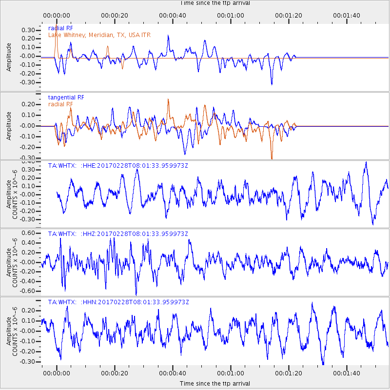
WHTX Lake Whitney, Meridian, TX, USA - Earthquake Result Viewer
*The percent match for this event was below the threshold and hence no stack was calculated.
| Earthquake location: |
Near East Coast Of Honshu, Japan |
| Earthquake latitude/longitude: |
37.6/141.3 |
| Earthquake time(UTC): |
2017/02/28 (059) 07:49:01 GMT |
| Earthquake Depth: |
38 km |
| Earthquake Magnitude: |
5.7 Mww |
| Earthquake Catalog/Contributor: |
NEIC PDE/us |
|
| Network: |
TA USArray Transportable Network (new EarthScope stations) |
| Station: |
WHTX Lake Whitney, Meridian, TX, USA |
| Lat/Lon: |
31.99 N/97.46 W |
| Elevation: |
190 m |
|
| Distance: |
91.7 deg |
| Az: |
46.62 deg |
| Baz: |
317.182 deg |
| Ray Param: |
$rayparam |
*The percent match for this event was below the threshold and hence was not used in the summary stack. |
|
| Radial Match: |
71.08768 % |
| Radial Bump: |
400 |
| Transverse Match: |
39.653446 % |
| Transverse Bump: |
400 |
| SOD ConfigId: |
11737051 |
| Insert Time: |
2019-04-26 20:30:52.048 +0000 |
| GWidth: |
2.5 |
| Max Bumps: |
400 |
| Tol: |
0.001 |
|
Signal To Noise
| Channel | StoN | STA | LTA |
| TA:WHTX: :HHZ:20170228T08:01:33.959973Z | 1.9342527 | 2.485764E-7 | 1.2851288E-7 |
| TA:WHTX: :HHN:20170228T08:01:33.959973Z | 1.1831697 | 1.4770238E-7 | 1.2483618E-7 |
| TA:WHTX: :HHE:20170228T08:01:33.959973Z | 0.72470146 | 7.6459344E-8 | 1.05504604E-7 |
| Arrivals |
| Ps | |
| PpPs | |
| PsPs/PpSs | |


