You are here: Home > Network List > UW - Pacific Northwest Regional Seismic Network Stations List
> Station UMAT Pilot Rock, OR, USA > Earthquake Result Viewer
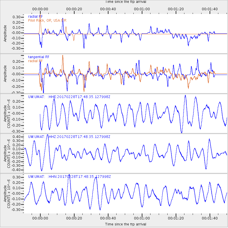
UMAT Pilot Rock, OR, USA - Earthquake Result Viewer
*The percent match for this event was below the threshold and hence no stack was calculated.
| Earthquake location: |
Off Coast Of Southern Chile |
| Earthquake latitude/longitude: |
-44.8/-80.9 |
| Earthquake time(UTC): |
2017/02/28 (059) 17:35:40 GMT |
| Earthquake Depth: |
10 km |
| Earthquake Magnitude: |
5.6 Mww |
| Earthquake Catalog/Contributor: |
NEIC PDE/us |
|
| Network: |
UW Pacific Northwest Regional Seismic Network |
| Station: |
UMAT Pilot Rock, OR, USA |
| Lat/Lon: |
45.29 N/118.96 W |
| Elevation: |
1318 m |
|
| Distance: |
95.8 deg |
| Az: |
334.072 deg |
| Baz: |
153.817 deg |
| Ray Param: |
$rayparam |
*The percent match for this event was below the threshold and hence was not used in the summary stack. |
|
| Radial Match: |
55.340504 % |
| Radial Bump: |
400 |
| Transverse Match: |
54.375607 % |
| Transverse Bump: |
400 |
| SOD ConfigId: |
11737051 |
| Insert Time: |
2019-04-26 20:39:47.350 +0000 |
| GWidth: |
2.5 |
| Max Bumps: |
400 |
| Tol: |
0.001 |
|
Signal To Noise
| Channel | StoN | STA | LTA |
| UW:UMAT: :HHZ:20170228T17:48:35.127998Z | 2.0227406 | 2.9491326E-7 | 1.4579886E-7 |
| UW:UMAT: :HHN:20170228T17:48:35.127998Z | 0.98453355 | 1.2332548E-7 | 1.2526284E-7 |
| UW:UMAT: :HHE:20170228T17:48:35.127998Z | 0.63057554 | 9.250532E-8 | 1.4669982E-7 |
| Arrivals |
| Ps | |
| PpPs | |
| PsPs/PpSs | |


