You are here: Home > Network List > CI - Caltech Regional Seismic Network Stations List
> Station VTV Victorville, California, USA > Earthquake Result Viewer
VTV Victorville, California, USA - Earthquake Result Viewer
| Earthquake location: |
New Ireland Region, P.N.G. |
| Earthquake latitude/longitude: |
-5.1/153.2 |
| Earthquake time(UTC): |
2000/11/16 (321) 05:47:34 GMT |
| Earthquake Depth: |
33 km |
| Earthquake Magnitude: |
5.6 MB |
| Earthquake Catalog/Contributor: |
WHDF/NEIC |
|
| Network: |
CI Caltech Regional Seismic Network |
| Station: |
VTV Victorville, California, USA |
| Lat/Lon: |
34.56 N/117.33 W |
| Elevation: |
812 m |
|
| Distance: |
92.4 deg |
| Az: |
55.691 deg |
| Baz: |
265.481 deg |
| Ray Param: |
0.041448195 |
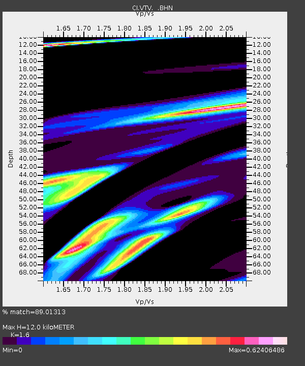
| Estimated Moho Depth: |
12.0 km |
| Estimated Crust Vp/Vs: |
1.60 |
| Assumed Crust Vp: |
6.276 km/s |
| Estimated Crust Vs: |
3.922 km/s |
| Estimated Crust Poisson's Ratio: |
0.18 |
|
| Radial Match: |
89.01313 % |
| Radial Bump: |
374 |
| Transverse Match: |
53.501587 % |
| Transverse Bump: |
400 |
| SOD ConfigId: |
3770 |
| Insert Time: |
2010-03-05 22:17:28.270 +0000 |
| GWidth: |
2.5 |
| Max Bumps: |
400 |
| Tol: |
0.001 |
|

Signal To Noise
| Channel | StoN | STA | LTA |
| CI:VTV: :BHN:20001116T06:00:10.308999Z | 0.5652071 | 5.706041E-6 | 1.0095487E-5 |
| CI:VTV: :BHE:20001116T06:00:10.308999Z | 1.3897263 | 1.5510832E-5 | 1.1161069E-5 |
| CI:VTV: :BHZ:20001116T06:00:10.308999Z | 0.39267683 | 8.602361E-6 | 2.1906973E-5 |
| Arrivals |
| Ps | 1.2 SECOND |
| PpPs | 4.9 SECOND |
| PsPs/PpSs | 6.0 SECOND |


