You are here: Home > Network List > CI - Caltech Regional Seismic Network Stations List
> Station VTV Victorville, California, USA > Earthquake Result Viewer
VTV Victorville, California, USA - Earthquake Result Viewer
| Earthquake location: |
Panama-Colombia Border Region |
| Earthquake latitude/longitude: |
7.0/-77.8 |
| Earthquake time(UTC): |
2000/11/08 (313) 06:59:58 GMT |
| Earthquake Depth: |
17 km |
| Earthquake Magnitude: |
6.0 MB, 6.4 MS, 6.5 MW, 6.2 ML |
| Earthquake Catalog/Contributor: |
WHDF/NEIC |
|
| Network: |
CI Caltech Regional Seismic Network |
| Station: |
VTV Victorville, California, USA |
| Lat/Lon: |
34.56 N/117.33 W |
| Elevation: |
812 m |
|
| Distance: |
45.5 deg |
| Az: |
312.612 deg |
| Baz: |
117.736 deg |
| Ray Param: |
0.0712151 |
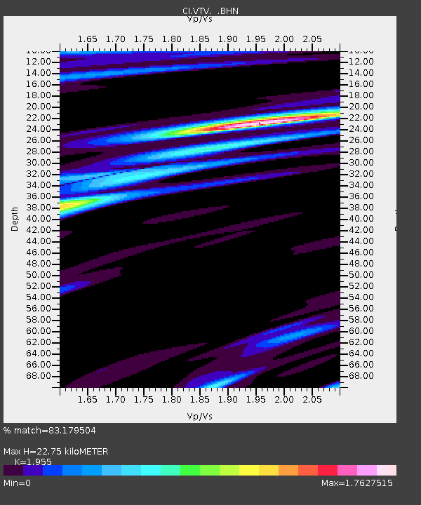
| Estimated Moho Depth: |
22.75 km |
| Estimated Crust Vp/Vs: |
1.96 |
| Assumed Crust Vp: |
6.276 km/s |
| Estimated Crust Vs: |
3.21 km/s |
| Estimated Crust Poisson's Ratio: |
0.32 |
|
| Radial Match: |
83.179504 % |
| Radial Bump: |
400 |
| Transverse Match: |
82.96762 % |
| Transverse Bump: |
400 |
| SOD ConfigId: |
3744 |
| Insert Time: |
2010-03-05 22:17:35.214 +0000 |
| GWidth: |
2.5 |
| Max Bumps: |
400 |
| Tol: |
0.001 |
|

Signal To Noise
| Channel | StoN | STA | LTA |
| CI:VTV: :BHN:20001108T07:07:46.409988Z | 0.7086454 | 2.3346874E-7 | 3.2945778E-7 |
| CI:VTV: :BHE:20001108T07:07:46.409988Z | 1.1170378 | 3.1917327E-7 | 2.8573186E-7 |
| CI:VTV: :BHZ:20001108T07:07:46.409988Z | 1.9245087 | 3.6387172E-7 | 1.8907252E-7 |
| Arrivals |
| Ps | 3.7 SECOND |
| PpPs | 10 SECOND |
| PsPs/PpSs | 14 SECOND |


