You are here: Home > Network List > CI - Caltech Regional Seismic Network Stations List
> Station VTV Victorville, California, USA > Earthquake Result Viewer
VTV Victorville, California, USA - Earthquake Result Viewer
| Earthquake location: |
Western Honshu, Japan |
| Earthquake latitude/longitude: |
35.5/133.1 |
| Earthquake time(UTC): |
2000/10/06 (280) 04:30:19 GMT |
| Earthquake Depth: |
10 km |
| Earthquake Magnitude: |
5.8 MB, 6.8 MS, 7.0 ME, 6.7 MW |
| Earthquake Catalog/Contributor: |
WHDF/NEIC |
|
| Network: |
CI Caltech Regional Seismic Network |
| Station: |
VTV Victorville, California, USA |
| Lat/Lon: |
34.56 N/117.33 W |
| Elevation: |
812 m |
|
| Distance: |
84.2 deg |
| Az: |
51.423 deg |
| Baz: |
309.346 deg |
| Ray Param: |
0.04564048 |
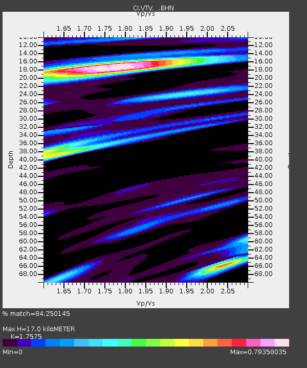
| Estimated Moho Depth: |
17.0 km |
| Estimated Crust Vp/Vs: |
1.76 |
| Assumed Crust Vp: |
6.276 km/s |
| Estimated Crust Vs: |
3.571 km/s |
| Estimated Crust Poisson's Ratio: |
0.26 |
|
| Radial Match: |
84.250145 % |
| Radial Bump: |
314 |
| Transverse Match: |
70.32064 % |
| Transverse Bump: |
400 |
| SOD ConfigId: |
3744 |
| Insert Time: |
2010-03-05 22:17:36.354 +0000 |
| GWidth: |
2.5 |
| Max Bumps: |
400 |
| Tol: |
0.001 |
|

Signal To Noise
| Channel | StoN | STA | LTA |
| CI:VTV: :BHN:20001006T04:42:19.209998Z | 1.1441448 | 1.571124E-7 | 1.3731864E-7 |
| CI:VTV: :BHE:20001006T04:42:19.209998Z | 0.89434534 | 1.9266245E-7 | 2.1542289E-7 |
| CI:VTV: :BHZ:20001006T04:42:19.209998Z | 1.5927072 | 2.466254E-7 | 1.5484667E-7 |
| Arrivals |
| Ps | 2.1 SECOND |
| PpPs | 7.3 SECOND |
| PsPs/PpSs | 9.4 SECOND |


