You are here: Home > Network List > CI - Caltech Regional Seismic Network Stations List
> Station VTV Victorville, California, USA > Earthquake Result Viewer
VTV Victorville, California, USA - Earthquake Result Viewer
| Earthquake location: |
Vanuatu Islands |
| Earthquake latitude/longitude: |
-15.4/166.9 |
| Earthquake time(UTC): |
2000/10/04 (278) 16:58:44 GMT |
| Earthquake Depth: |
23 km |
| Earthquake Magnitude: |
6.1 MB, 6.9 MS, 6.8 MW, 6.5 ME |
| Earthquake Catalog/Contributor: |
WHDF/NEIC |
|
| Network: |
CI Caltech Regional Seismic Network |
| Station: |
VTV Victorville, California, USA |
| Lat/Lon: |
34.56 N/117.33 W |
| Elevation: |
812 m |
|
| Distance: |
87.3 deg |
| Az: |
53.208 deg |
| Baz: |
249.364 deg |
| Ray Param: |
0.04337758 |
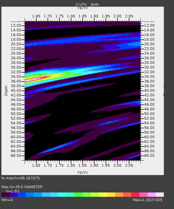
| Estimated Moho Depth: |
35.0 km |
| Estimated Crust Vp/Vs: |
1.63 |
| Assumed Crust Vp: |
6.276 km/s |
| Estimated Crust Vs: |
3.85 km/s |
| Estimated Crust Poisson's Ratio: |
0.20 |
|
| Radial Match: |
89.267075 % |
| Radial Bump: |
400 |
| Transverse Match: |
71.15753 % |
| Transverse Bump: |
400 |
| SOD ConfigId: |
3744 |
| Insert Time: |
2010-03-05 22:17:37.486 +0000 |
| GWidth: |
2.5 |
| Max Bumps: |
400 |
| Tol: |
0.001 |
|

Signal To Noise
| Channel | StoN | STA | LTA |
| CI:VTV: :BHN:20001004T17:10:57.810Z | 0.5834494 | 3.6698327E-7 | 6.28989E-7 |
| CI:VTV: :BHE:20001004T17:10:57.810Z | 0.5461392 | 4.581913E-7 | 8.389643E-7 |
| CI:VTV: :BHZ:20001004T17:10:57.810Z | 2.5699391 | 1.3602215E-6 | 5.2928164E-7 |
| Arrivals |
| Ps | 3.6 SECOND |
| PpPs | 14 SECOND |
| PsPs/PpSs | 18 SECOND |


