You are here: Home > Network List > IW - Intermountain West Stations List
> Station DLMT Dillon, Montana, USA > Earthquake Result Viewer
DLMT Dillon, Montana, USA - Earthquake Result Viewer
*The percent match for this event was below the threshold and hence no stack was calculated.
| Earthquake location: |
North Of Honduras |
| Earthquake latitude/longitude: |
17.8/-81.8 |
| Earthquake time(UTC): |
2015/11/16 (320) 00:39:33 GMT |
| Earthquake Depth: |
9.1 km |
| Earthquake Magnitude: |
5.8 MWP |
| Earthquake Catalog/Contributor: |
NEIC PDE/NEIC COMCAT |
|
| Network: |
IW Intermountain West |
| Station: |
DLMT Dillon, Montana, USA |
| Lat/Lon: |
45.36 N/112.60 W |
| Elevation: |
1569 m |
|
| Distance: |
37.5 deg |
| Az: |
323.709 deg |
| Baz: |
126.902 deg |
| Ray Param: |
$rayparam |
*The percent match for this event was below the threshold and hence was not used in the summary stack. |
|
| Radial Match: |
76.61486 % |
| Radial Bump: |
389 |
| Transverse Match: |
61.934944 % |
| Transverse Bump: |
355 |
| SOD ConfigId: |
1259291 |
| Insert Time: |
2015-11-30 01:36:46.473 +0000 |
| GWidth: |
2.5 |
| Max Bumps: |
400 |
| Tol: |
0.001 |
|
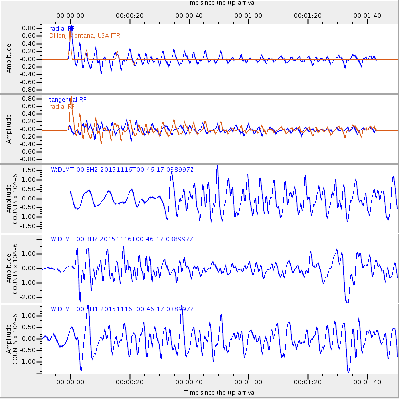
Signal To Noise
| Channel | StoN | STA | LTA |
| IW:DLMT:00:BHZ:20151116T00:46:17.038997Z | 3.5752919 | 8.171776E-7 | 2.2856248E-7 |
| IW:DLMT:00:BH1:20151116T00:46:17.038997Z | 2.78562 | 5.57589E-7 | 2.0016691E-7 |
| IW:DLMT:00:BH2:20151116T00:46:17.038997Z | 2.3422585 | 7.088201E-7 | 3.026225E-7 |
| Arrivals |
| Ps | |
| PpPs | |
| PsPs/PpSs | |


