You are here: Home > Network List > CI - Caltech Regional Seismic Network Stations List
> Station VTV Victorville, California, USA > Earthquake Result Viewer
VTV Victorville, California, USA - Earthquake Result Viewer
| Earthquake location: |
South Of Fiji Islands |
| Earthquake latitude/longitude: |
-23.6/178.5 |
| Earthquake time(UTC): |
2002/08/19 (231) 11:03:13 GMT |
| Earthquake Depth: |
650 km |
| Earthquake Magnitude: |
5.9 MB |
| Earthquake Catalog/Contributor: |
WHDF/NEIC |
|
| Network: |
CI Caltech Regional Seismic Network |
| Station: |
VTV Victorville, California, USA |
| Lat/Lon: |
34.56 N/117.33 W |
| Elevation: |
812 m |
|
| Distance: |
83.9 deg |
| Az: |
48.313 deg |
| Baz: |
236.127 deg |
| Ray Param: |
0.043875683 |
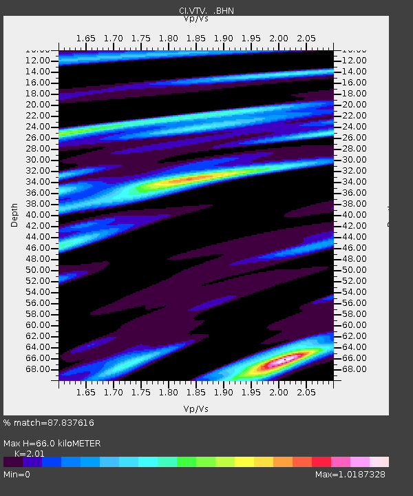
| Estimated Moho Depth: |
66.0 km |
| Estimated Crust Vp/Vs: |
2.01 |
| Assumed Crust Vp: |
6.276 km/s |
| Estimated Crust Vs: |
3.122 km/s |
| Estimated Crust Poisson's Ratio: |
0.34 |
|
| Radial Match: |
87.837616 % |
| Radial Bump: |
340 |
| Transverse Match: |
72.13937 % |
| Transverse Bump: |
400 |
| SOD ConfigId: |
3770 |
| Insert Time: |
2010-03-05 22:18:04.306 +0000 |
| GWidth: |
2.5 |
| Max Bumps: |
400 |
| Tol: |
0.001 |
|

Signal To Noise
| Channel | StoN | STA | LTA |
| CI:VTV: :BHN:20020819T11:14:05.698018Z | 3.2583802 | 3.528045E-6 | 1.0827604E-6 |
| CI:VTV: :BHE:20020819T11:14:05.698018Z | 3.1239026 | 4.1486733E-6 | 1.3280419E-6 |
| CI:VTV: :BHZ:20020819T11:14:05.698018Z | 4.451885 | 1.2824977E-5 | 2.8807965E-6 |
| Arrivals |
| Ps | 11 SECOND |
| PpPs | 31 SECOND |
| PsPs/PpSs | 42 SECOND |


