You are here: Home > Network List > CI - Caltech Regional Seismic Network Stations List
> Station VTV Victorville, California, USA > Earthquake Result Viewer
VTV Victorville, California, USA - Earthquake Result Viewer
| Earthquake location: |
Northwest Of Kuril Islands |
| Earthquake latitude/longitude: |
47.8/146.2 |
| Earthquake time(UTC): |
2002/11/17 (321) 04:53:53 GMT |
| Earthquake Depth: |
459 km |
| Earthquake Magnitude: |
7.3 MW, 7.3 MW |
| Earthquake Catalog/Contributor: |
WHDF/NEIC |
|
| Network: |
CI Caltech Regional Seismic Network |
| Station: |
VTV Victorville, California, USA |
| Lat/Lon: |
34.56 N/117.33 W |
| Elevation: |
812 m |
|
| Distance: |
69.2 deg |
| Az: |
61.29 deg |
| Baz: |
314.263 deg |
| Ray Param: |
0.054282393 |
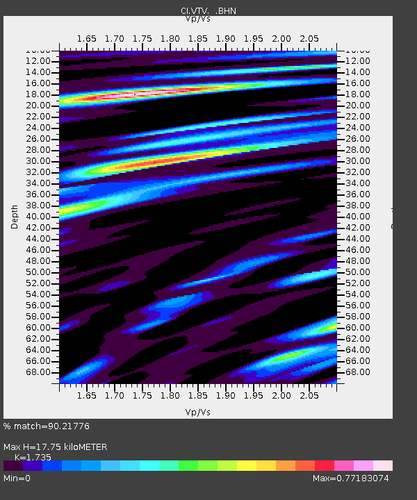
| Estimated Moho Depth: |
17.75 km |
| Estimated Crust Vp/Vs: |
1.74 |
| Assumed Crust Vp: |
6.276 km/s |
| Estimated Crust Vs: |
3.617 km/s |
| Estimated Crust Poisson's Ratio: |
0.25 |
|
| Radial Match: |
90.21776 % |
| Radial Bump: |
400 |
| Transverse Match: |
88.67805 % |
| Transverse Bump: |
400 |
| SOD ConfigId: |
4714 |
| Insert Time: |
2010-03-05 22:18:09.160 +0000 |
| GWidth: |
2.5 |
| Max Bumps: |
400 |
| Tol: |
0.001 |
|

Signal To Noise
| Channel | StoN | STA | LTA |
| CI:VTV: :BHN:20021117T05:03:42.32302Z | 25.11089 | 1.0445156E-5 | 4.1596118E-7 |
| CI:VTV: :BHE:20021117T05:03:42.32302Z | 22.502707 | 9.360388E-6 | 4.1596718E-7 |
| CI:VTV: :BHZ:20021117T05:03:42.32302Z | 106.990715 | 3.7512338E-5 | 3.5061302E-7 |
| Arrivals |
| Ps | 2.2 SECOND |
| PpPs | 7.5 SECOND |
| PsPs/PpSs | 9.6 SECOND |


